
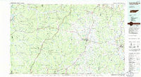
~ Lawrenceburg TN topo map, 1:100000 scale, 30 X 60 Minute, Historical, 1985, updated 1985
Lawrenceburg, Tennessee, USGS topographic map dated 1985.
Includes geographic coordinates (latitude and longitude). This topographic map is suitable for hiking, camping, and exploring, or framing it as a wall map.
Printed on-demand using high resolution imagery, on heavy weight and acid free paper, or alternatively on a variety of synthetic materials.
Topos available on paper, Waterproof, Poly, or Tyvek. Usually shipping rolled, unless combined with other folded maps in one order.
- Product Number: USGS-5338854
- Free digital map download (high-resolution, GeoPDF): Lawrenceburg, Tennessee (file size: 16 MB)
- Map Size: please refer to the dimensions of the GeoPDF map above
- Weight (paper map): ca. 55 grams
- Map Type: POD USGS Topographic Map
- Map Series: HTMC
- Map Verison: Historical
- Cell ID: 67830
- Scan ID: 144014
- Imprint Year: 1985
- Woodland Tint: Yes
- Aerial Photo Year: 1981
- Edit Year: 1985
- Datum: NAD27
- Map Projection: Universal Transverse Mercator
- Planimetric: Yes
- Map published by Tennessee Valley Authority
- Map Language: English
- Scanner Resolution: 600 dpi
- Map Cell Name: Lawrenceburg
- Grid size: 30 X 60 Minute
- Date on map: 1985
- Map Scale: 1:100000
- Geographical region: Tennessee, United States
Neighboring Maps:
All neighboring USGS topo maps are available for sale online at a variety of scales.
Spatial coverage:
Topo map Lawrenceburg, Tennessee, covers the geographical area associated the following places:
- Ethridge - Olivet - Bethlehem - Sims Ridge - Lindauer (historical) - Dogwood Heights - Rhoades Hill (historical) - Brace - Bird Mill - Prospect - Ashland - Anthony Hill - Brier Hill - Iron City - Turney - Crossroads - Stiversville - Campbellsville - Cole (historical) - Waco - Red Hill - Loretto - Webber City - Cyclone (historical) - Richland Trace Subdivision - Scotts Mill - Ruppertown - Topsy - Flatwoods - Center - Oak Grove - Union Hill - Brown Crossroads - Peppertown - Revilo - Corning (historical) - Appleton - Saint Marys - Riverside - Crossroads - Wales - Crossroads - Stella - Moon (historical) - Waynesboro - Lutts - Gipsonville - Gileston (historical) - Crescent View - Quercus - Stout - Leoma - Starkey (historical) - Strathmore (historical) - Mooney - Lower Holly Creek - Hardwick Subdivision - Highland Heights - Sandy Hook - Crewstown - Three Oaks - Lynnville - Mount Zion - Browntown (historical) - Turkey Track - Center Point - Valleyview Subdivision - Jonestown - Mount Nebo - Southport - Sweetwater - Fall River - Antioch - Collinwood - Hensley Ridge (historical) - Dunn - Yokley - Shawnette - Ransom Stand - Cromwell Crossroads - McGlamery Stand - Ovilla - Lancelot Acres - Lovie (historical) - Henryville - Broadview - Summertown - Idaho - Green Field - Rebel Acres - Rockdale - Springers Station - Lodi - Glendale - Lower Mockeson - Rich - Rockquarry (historical) - Gandy - Fairview - Chapmans
- Map Area ID: AREA35.535-88-87
- Northwest corner Lat/Long code: USGSNW35.5-88
- Northeast corner Lat/Long code: USGSNE35.5-87
- Southwest corner Lat/Long code: USGSSW35-88
- Southeast corner Lat/Long code: USGSSE35-87
- Northern map edge Latitude: 35.5
- Southern map edge Latitude: 35
- Western map edge Longitude: -88
- Eastern map edge Longitude: -87


