
~ Hohenwald TN topo map, 1:100000 scale, 30 X 60 Minute, Historical, 1986, updated 1993
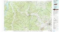
Hohenwald, Tennessee, USGS topographic map dated 1986.
Includes geographic coordinates (latitude and longitude). This topographic map is suitable for hiking, camping, and exploring, or framing it as a wall map.
Printed on-demand using high resolution imagery, on heavy weight and acid free paper, or alternatively on a variety of synthetic materials.
Topos available on paper, Waterproof, Poly, or Tyvek. Usually shipping rolled, unless combined with other folded maps in one order.
- Product Number: USGS-5338844
- Free digital map download (high-resolution, GeoPDF): Hohenwald, Tennessee (file size: 29 MB)
- Map Size: please refer to the dimensions of the GeoPDF map above
- Weight (paper map): ca. 55 grams
- Map Type: POD USGS Topographic Map
- Map Series: HTMC
- Map Verison: Historical
- Cell ID: 67673
- Scan ID: 143962
- Imprint Year: 1993
- Woodland Tint: Yes
- Visual Version Number: 1
- Aerial Photo Year: 1981
- Edit Year: 1986
- Datum: NAD27
- Map Projection: Universal Transverse Mercator
- Map published by Tennessee Valley Authority
- Map Language: English
- Scanner Resolution: 600 dpi
- Map Cell Name: Hohenwald
- Grid size: 30 X 60 Minute
- Date on map: 1986
- Map Scale: 1:100000
- Geographical region: Tennessee, United States
Neighboring Maps:
All neighboring USGS topo maps are available for sale online at a variety of scales.
Spatial coverage:
Topo map Hohenwald, Tennessee, covers the geographical area associated the following places:
- Mount Pleasant - Boston - Bigby (historical) - McCains - Caigletown - Creek Side - Daugherty Estates - Bucksnort - Highland Heights - Fairview Heights - Hill Town - Valley Green Estates - Aetna - Ashwood - Canaan - Lick Creek (historical) - Poplar Creek - Matlock Ford - New Flys Village - Crooked Creek - Meadowwood Acres - Lobelville - Mount Joy - Columbia - Milltown - Lucerne (historical) - Graytown - Beaverdam Springs - Buffalo - Graham - Wills Chapel - Springer Ridge (historical) - Zion - Lone Oak - Fernvale Springs (historical) - Grove - DePriest Bend - Jameson - Woodland Heights - Flint Valley (historical) - Grammer Estates - Abiff - Rolling Fields - Toms Creek (historical) - Theodore - Chapel Hill - Sulphur Springs (historical) - Lebanon Heights - Eagle Creek - Coble - Whitfield - Red Row - Redden (historical) - Hohenwald - Primm Springs - Poplar Top - Sulphur Springs (historical) - Spencers Mill - Bon Aqua Junction - Godwin - New Era (historical) - West Haven - Salem - Green Valley - Gant - Watson - Kettle Mills - Whitehouse - Hampshire - Concord (historical) - Linden - Furnace - Highland Park - Craigfield - River Heights - Beale (historical) - Columbia Gardens - Gordonsburg - Hopewell - Santa Fe - Bigbyville - Lakeview Estates - Kimmins - Pleasant Hills - Ridley - Athendale - Cotham (historical) - Vernon - Greenbrier - Arrow - Riverside - Ben (historical) - Nunnelly - Forrest Hills - Hustburg - Bel Air - Kinderhook - Aethra - Shubert - Little Rock Mills
- Map Area ID: AREA3635.5-88-87
- Northwest corner Lat/Long code: USGSNW36-88
- Northeast corner Lat/Long code: USGSNE36-87
- Southwest corner Lat/Long code: USGSSW35.5-88
- Southeast corner Lat/Long code: USGSSE35.5-87
- Northern map edge Latitude: 36
- Southern map edge Latitude: 35.5
- Western map edge Longitude: -88
- Eastern map edge Longitude: -87


