
~ Dickson TN topo map, 1:100000 scale, 30 X 60 Minute, Historical, 1985, updated 1985
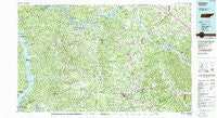
Dickson, Tennessee, USGS topographic map dated 1985.
Includes geographic coordinates (latitude and longitude). This topographic map is suitable for hiking, camping, and exploring, or framing it as a wall map.
Printed on-demand using high resolution imagery, on heavy weight and acid free paper, or alternatively on a variety of synthetic materials.
Topos available on paper, Waterproof, Poly, or Tyvek. Usually shipping rolled, unless combined with other folded maps in one order.
- Product Number: USGS-5338840
- Free digital map download (high-resolution, GeoPDF): Dickson, Tennessee (file size: 31 MB)
- Map Size: please refer to the dimensions of the GeoPDF map above
- Weight (paper map): ca. 55 grams
- Map Type: POD USGS Topographic Map
- Map Series: HTMC
- Map Verison: Historical
- Cell ID: 67420
- Scan ID: 143870
- Imprint Year: 1985
- Woodland Tint: Yes
- Aerial Photo Year: 1981
- Edit Year: 1985
- Datum: NAD27
- Map Projection: Universal Transverse Mercator
- Map published by Tennessee Valley Authority
- Map Language: English
- Scanner Resolution: 600 dpi
- Map Cell Name: Dickson
- Grid size: 30 X 60 Minute
- Date on map: 1985
- Map Scale: 1:100000
- Geographical region: Tennessee, United States
Neighboring Maps:
All neighboring USGS topo maps are available for sale online at a variety of scales.
Spatial coverage:
Topo map Dickson, Tennessee, covers the geographical area associated the following places:
- Deerfield - Thompsons Crossroads - Brush Creek - Brownsville - Beech Grove - Carlisle - Erin - Hillcrest - Nosegay (historical) - Germantown - Turnersville - Marrowbone - Bell Hollow (historical) - Dotsonville - Hortense - Cheap Hill - Antioch - Craggie Hope - Pollard - Taylor Crossroads - Jason Chapel - Stewart - Ellis Mills - Harpeth Valley - Medallion Acres - Pigeon Roost - Cumberland Hills - Big Springs - Oakridge - Lakeside Estates - Water Valley (historical) - Lockertsville - Asbury - Oaklawn - Cumberland City - Spring Hill - Concord - McAllisters Crossroads - Coaling - Linton - Kingsbury - Pleasant View - Griffin (historical) - Midway - Waverly - Petway - Round Pond - Spring Valley - Palmyra - Jackson Chapel - Acorn Hill - Halls Creek - Stony Point - Stroudville - Liners - Griffintown - Southside - Fleetvile (historical) - Chapmansboro - Dickson - Bellamy (historical) - Bell Town - Fewville (historical) - Cunningham - Claud (historical) - Cotton Patch Crossroads - Lewis Branch - Forest Hill - Plant - Bellsburg - Harris Hollow - Betsystown (historical) - Hopkins Crossing - New Hope - McEwen - Lillamay - Edgewood - Bethlehem - Corbandale - Ashland City - White Oak Flat - Liberty - Forest Acres - Magnolia - Cave Spring - Vanleer - Dunn Chapel - West Dickson - Dannertown - Doddsville - Oak Grove - Robinsons Chapel - Cumberland Furnace - New Hope - Orgains Crossroads - Salem - Needmore - Few Chapel - Forks of Piney (historical) - Sailors Rest (historical)
- Map Area ID: AREA36.536-88-87
- Northwest corner Lat/Long code: USGSNW36.5-88
- Northeast corner Lat/Long code: USGSNE36.5-87
- Southwest corner Lat/Long code: USGSSW36-88
- Southeast corner Lat/Long code: USGSSE36-87
- Northern map edge Latitude: 36.5
- Southern map edge Latitude: 36
- Western map edge Longitude: -88
- Eastern map edge Longitude: -87


