
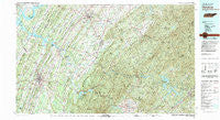
~ Cleveland TN topo map, 1:100000 scale, 30 X 60 Minute, Historical, 1981, updated 1981
Cleveland, Tennessee, USGS topographic map dated 1981.
Includes geographic coordinates (latitude and longitude). This topographic map is suitable for hiking, camping, and exploring, or framing it as a wall map.
Printed on-demand using high resolution imagery, on heavy weight and acid free paper, or alternatively on a variety of synthetic materials.
Topos available on paper, Waterproof, Poly, or Tyvek. Usually shipping rolled, unless combined with other folded maps in one order.
- Product Number: USGS-5338838
- Free digital map download (high-resolution, GeoPDF): Cleveland, Tennessee (file size: 32 MB)
- Map Size: please refer to the dimensions of the GeoPDF map above
- Weight (paper map): ca. 55 grams
- Map Type: POD USGS Topographic Map
- Map Series: HTMC
- Map Verison: Historical
- Cell ID: 67309
- Scan ID: 148986
- Imprint Year: 1981
- Woodland Tint: Yes
- Visual Version Number: 2
- Aerial Photo Year: 1976
- Edit Year: 1981
- Datum: NAD27
- Map Projection: Universal Transverse Mercator
- Map published by Tennessee Valley Authority
- Map Language: English
- Scanner Resolution: 600 dpi
- Map Cell Name: Cleveland
- Grid size: 30 X 60 Minute
- Date on map: 1981
- Map Scale: 1:100000
- Geographical region: Tennessee, United States
Neighboring Maps:
All neighboring USGS topo maps are available for sale online at a variety of scales.
Spatial coverage:
Topo map Cleveland, Tennessee, covers the geographical area associated the following places:
- Goodsprings - Holly Springs - Bohannon Addition - Maggies Mill - Prospect - Athens - Reesetown - Tellico Beach - Fairview - Windwood - Oak Grove - Westwood Heights - Grady - Twin Oaks - Ivy - Georgetown - Hiwassee Village - Brittsville - Reliance - Coker Creek - Westview Heights - Parks Store - Citico (historical) - Dockery - Oakwood - Bigsby Creek Estates - North Liberty - Ebenezer - Felker - Chestnut Valley - Fetzerton (historical) - Colonial Estates - Cayuga Town (historical) - Cedar Spring - Mashburn - Birchwood - Folger (historical) - Gibson Farm Subdivision - Claxton - Waterville - Ball Play - Poplar Hill - Ridgewood - Cedar Springs - Bent Tree Acres - Violet - Conasauga - Delano - Isabella - Baugh Spring - Ebenezer - Boiling Springs - Seven Cedars - Cleveland - Ocoee - Double Springs - Letitia - Oak Park - Mount Verd - Old Patty - Liberty Hill - Stewardtown (historical) - Idlewild - Liberty - Homestead Acres - Servilla - Grandview - Hiwassee - Wetmore - Earnest (historical) - Ridgeway - Rural Vale - Hambright - Rolling Hills - Mount Cumberland - Benton - Housley Addition - Arden - Avalon Heights - Ironsburg - Grief (historical) - Chestuee - Flint Springs - Annadale - Kimsey - Big Spring - Fairview - Hills and Dales - Smithfield - Monte Carlo Estates - Kingwood Estates - Villa Heights - McGeetown - Rocky Spring - Bryson - Sugar Grove - Johnston Circle - Mapleton Hills - Manila - Chanceytown
- Map Area ID: AREA35.535-85-84
- Northwest corner Lat/Long code: USGSNW35.5-85
- Northeast corner Lat/Long code: USGSNE35.5-84
- Southwest corner Lat/Long code: USGSSW35-85
- Southeast corner Lat/Long code: USGSSE35-84
- Northern map edge Latitude: 35.5
- Southern map edge Latitude: 35
- Western map edge Longitude: -85
- Eastern map edge Longitude: -84


