
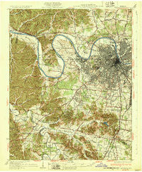
~ Nashville TN topo map, 1:62500 scale, 15 X 15 Minute, Historical, 1932
Nashville, Tennessee, USGS topographic map dated 1932.
Includes geographic coordinates (latitude and longitude). This topographic map is suitable for hiking, camping, and exploring, or framing it as a wall map.
Printed on-demand using high resolution imagery, on heavy weight and acid free paper, or alternatively on a variety of synthetic materials.
Topos available on paper, Waterproof, Poly, or Tyvek. Usually shipping rolled, unless combined with other folded maps in one order.
- Product Number: USGS-5338774
- Free digital map download (high-resolution, GeoPDF): Nashville, Tennessee (file size: 11 MB)
- Map Size: please refer to the dimensions of the GeoPDF map above
- Weight (paper map): ca. 55 grams
- Map Type: POD USGS Topographic Map
- Map Series: HTMC
- Map Verison: Historical
- Cell ID: 58279
- Scan ID: 153396
- Woodland Tint: Yes
- Survey Year: 1929
- Datum: NAD
- Map Projection: Polyconic
- Map published by United States Geological Survey
- Map Language: English
- Scanner Resolution: 600 dpi
- Map Cell Name: Nashville
- Grid size: 15 X 15 Minute
- Date on map: 1932
- Map Scale: 1:62500
- Geographical region: Tennessee, United States
Neighboring Maps:
All neighboring USGS topo maps are available for sale online at a variety of scales.
Spatial coverage:
Topo map Nashville, Tennessee, covers the geographical area associated the following places:
- East Nashville - Wildwood Estates - Battlewood Forest - Poplar Hills - Smyrna Road Homes - Mizell (historical) - Newsom - Dunkled Estates - Cambridge Hills - Cloverland Acres - Bordeaux Hills - Belle Rive Highlands - Hidden Valley Estates - Bordeaux - Beachville (historical) - Trace End Estates - Richland - Longwood - Sunnyside Estates - Cherokee Park - Phillips - Natchez Hills Estate - Parkwood Estates - Doziers (historical) - Oak Hampton - Sneed Glen - Brentwood - Metropolitan Government of Nashville-Davidson (balance) - Murray Estates - Nashville - Iroquois Meadows - Tennessee Towne (historical) - Iroquois Estates - Meadowlake - West Meade - Brentwood Estates - Hillview Estates - Bethany Hills - Forest Hills - Land Mark - Murray Lane Estates - Vaughns Gap - Pasquo - Hunters Ridge - Seventeen Seventysix Estates - Heathrow Hills - Carondelet - Belle Rive - Sneed Forest Estates - Benbar - Fountainhead - Cumberland Heights - River Oak Estates - Deerwood - Red Bud - Forest of Brentwood - Temple Hills Country Club Estates - Pickens Acres - Devonshire Manor - Avondale - Walnut Hills - Glendale Park - Harpeth River Estates - Brentwood Park - Oak Hill Estates - West Nashville - Buena Vista Estates - Grassland Estates - Williamson Estates - Belle Meade - Dekemont Downs - Heathrow - Harpeth Estates - Williamsburg Estates - Crieve Hall - Bethlehem - Steeple Chase Farms - Watkins (historical) - Foxland Hall - Scottsboro - Laurel Wood Estates - Charlotte Park - Hunters Hill - Green Hills - Bellevue - Berry Hill - River Rest - Hillsboro Valley - Brentwood Station - Jordonia - Derby Glen - Country Club Estates - Brooklyn Heights - Oak Hill
- Map Area ID: AREA36.2536-87-86.75
- Northwest corner Lat/Long code: USGSNW36.25-87
- Northeast corner Lat/Long code: USGSNE36.25-86.75
- Southwest corner Lat/Long code: USGSSW36-87
- Southeast corner Lat/Long code: USGSSE36-86.75
- Northern map edge Latitude: 36.25
- Southern map edge Latitude: 36
- Western map edge Longitude: -87
- Eastern map edge Longitude: -86.75


