
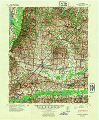
~ Millington TN topo map, 1:62500 scale, 15 X 15 Minute, Historical, 1942, updated 1954
Millington, Tennessee, USGS topographic map dated 1942.
Includes geographic coordinates (latitude and longitude). This topographic map is suitable for hiking, camping, and exploring, or framing it as a wall map.
Printed on-demand using high resolution imagery, on heavy weight and acid free paper, or alternatively on a variety of synthetic materials.
Topos available on paper, Waterproof, Poly, or Tyvek. Usually shipping rolled, unless combined with other folded maps in one order.
- Product Number: USGS-5338754
- Free digital map download (high-resolution, GeoPDF): Millington, Tennessee (file size: 10 MB)
- Map Size: please refer to the dimensions of the GeoPDF map above
- Weight (paper map): ca. 55 grams
- Map Type: POD USGS Topographic Map
- Map Series: HTMC
- Map Verison: Historical
- Cell ID: 57668
- Scan ID: 150065
- Imprint Year: 1954
- Woodland Tint: Yes
- Datum: NAD27
- Map Projection: Polyconic
- Map published by United States Army Corps of Engineers
- Map published by United States Department of War
- Map Language: English
- Scanner Resolution: 600 dpi
- Map Cell Name: Millington
- Grid size: 15 X 15 Minute
- Date on map: 1942
- Map Scale: 1:62500
- Geographical region: Tennessee, United States
Neighboring Maps:
All neighboring USGS topo maps are available for sale online at a variety of scales.
Spatial coverage:
Topo map Millington, Tennessee, covers the geographical area associated the following places:
- Pearley (historical) - Hopewell - Towering Heights - Atoka - Wilkinsville - Millington - Woodstock - Lucy - Bolton - Quito - Egypt - Rosemark - Kerrville - Munford - Crosstown - Little John - West Union - Williams Chapel - Saint Paul - Barretville - Peckerwood Point - Cuba - Prosperity - Drummonds - Dixonville - Bush Grove - Sloanville - Akins Corner - Griffin Corner - Brunswick - Gildfield - Tipton - Hagys Corner
- Map Area ID: AREA35.535.25-90-89.75
- Northwest corner Lat/Long code: USGSNW35.5-90
- Northeast corner Lat/Long code: USGSNE35.5-89.75
- Southwest corner Lat/Long code: USGSSW35.25-90
- Southeast corner Lat/Long code: USGSSE35.25-89.75
- Northern map edge Latitude: 35.5
- Southern map edge Latitude: 35.25
- Western map edge Longitude: -90
- Eastern map edge Longitude: -89.75


