
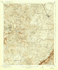
~ Crossville TN topo map, 1:62500 scale, 15 X 15 Minute, Historical, 1912, updated 1941
Crossville, Tennessee, USGS topographic map dated 1912.
Includes geographic coordinates (latitude and longitude). This topographic map is suitable for hiking, camping, and exploring, or framing it as a wall map.
Printed on-demand using high resolution imagery, on heavy weight and acid free paper, or alternatively on a variety of synthetic materials.
Topos available on paper, Waterproof, Poly, or Tyvek. Usually shipping rolled, unless combined with other folded maps in one order.
- Product Number: USGS-5338652
- Free digital map download (high-resolution, GeoPDF): Crossville, Tennessee (file size: 10 MB)
- Map Size: please refer to the dimensions of the GeoPDF map above
- Weight (paper map): ca. 55 grams
- Map Type: POD USGS Topographic Map
- Map Series: HTMC
- Map Verison: Historical
- Cell ID: 53107
- Scan ID: 149638
- Imprint Year: 1941
- Survey Year: 1910
- Datum: Unstated
- Map Projection: Polyconic
- Map published by United States Geological Survey
- Map Language: English
- Scanner Resolution: 600 dpi
- Map Cell Name: Crossville
- Grid size: 15 X 15 Minute
- Date on map: 1912
- Map Scale: 1:62500
- Geographical region: Tennessee, United States
Neighboring Maps:
All neighboring USGS topo maps are available for sale online at a variety of scales.
Spatial coverage:
Topo map Crossville, Tennessee, covers the geographical area associated the following places:
- Legget (historical) - Sunset Terrace - Shiloh - Howard Springs - Dykes Crossroads - Pinedale - Middle Brook Place - Oneida Subdivision - Phillps Subdivision - Music (historical) - Todd Town - Parkview - Burgesstown (historical) - Ojibwa Subdivision - Neverfail (historical) - Port Haven - Obed River Estates - Hillcrest - Holiday Hills - Storie - Maplewood Estates - Lake Tansi Village - Crossville - Hiawatha Subdivision - Mount Gilead (historical) - Pleasant Hill - The Meadows - Meadowview - Browntown - Comanche Subdivision - Lanatana Estates - Vandever - Woodlawn - Foxfire - Grassland Addition - Parham - Jan Mor Acres - Oak Hill - Woodstock Estates - Hale Mill - Hide-A-Way Hills - Midway - Smith Chapel - Lake Park - Grapevine (historical) - Shangrala - White Oak Forest - South Hills - Kiowa Subdivision - West Mill - Harrison Addition - Old Winesap - Caney Forks - Volunteer Heights - Wild Plum - Wyatt (historical) - Glendale - New Era - Hilltop Acres - Pleasant View Estates - Thomas Springs - Burke - Cumberland Heights - Lake Genesis Country - Crossville Estates - Winesap - Brookhaven - Camelot - Lake Tansi - Sparta Heights - Parkway Estates - Timberland Estates - Heritage Estates - Lantana - Erasmus - Eastland - Ridgedale - Baker Crossroads - Clifty - Hale - Mitchel Heights - Seminole Subdivision - Winnebago Subdivision - Big Lick - Town Branch Estates - Fairyland - Dunrovin Estates - Lynwood Acres - Highland Estates - Herbert Domain - Newton - Nicholson Heights - Livesay - Pomona - Taylors Chapel - Hickory Hills - Greenbriar Village - Sherwood Farm - Claysville - Oak Grove
- Map Area ID: AREA3635.75-85.25-85
- Northwest corner Lat/Long code: USGSNW36-85.25
- Northeast corner Lat/Long code: USGSNE36-85
- Southwest corner Lat/Long code: USGSSW35.75-85.25
- Southeast corner Lat/Long code: USGSSE35.75-85
- Northern map edge Latitude: 36
- Southern map edge Latitude: 35.75
- Western map edge Longitude: -85.25
- Eastern map edge Longitude: -85


