
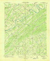
~ Surgoinsville TN topo map, 1:48000 scale, 15 X 15 Minute, Historical, 1935
Surgoinsville, Tennessee, USGS topographic map dated 1935.
Includes geographic coordinates (latitude and longitude). This topographic map is suitable for hiking, camping, and exploring, or framing it as a wall map.
Printed on-demand using high resolution imagery, on heavy weight and acid free paper, or alternatively on a variety of synthetic materials.
Topos available on paper, Waterproof, Poly, or Tyvek. Usually shipping rolled, unless combined with other folded maps in one order.
- Product Number: USGS-5338620
- Free digital map download (high-resolution, GeoPDF): Surgoinsville, Tennessee (file size: 8 MB)
- Map Size: please refer to the dimensions of the GeoPDF map above
- Weight (paper map): ca. 55 grams
- Map Type: POD USGS Topographic Map
- Map Series: HTMC
- Map Verison: Historical
- Cell ID: 74464
- Scan ID: 155924
- Woodland Tint: Yes
- Field Check Year: 1935
- Datum: NAD27
- Map Projection: Polyconic
- Advance: Yes
- Planimetric: Yes
- Map published by Tennessee Valley Authority
- Map Language: English
- Scanner Resolution: 600 dpi
- Map Cell Name: Surgoinsville
- Grid size: 15 X 15 Minute
- Date on map: 1935
- Map Scale: 1:48000
- Geographical region: Tennessee, United States
Neighboring Maps:
All neighboring USGS topo maps are available for sale online at a variety of scales.
Spatial coverage:
Topo map Surgoinsville, Tennessee, covers the geographical area associated the following places:
- McDonald Hill - Mount Carmel - Gillenwater (historical) - Ottway - Mount Hope (historical) - Blossom - Grigsby - Craft Spring - Honeycutt - Castell Springs - Kincheloe (historical) - Petersburg - Brittontown - Butcher (historical) - Pilot Knob - Stony Point - Couch (historical) - Spears (historical) - Strahl - Van Hill - Amis - Phipps Bend - McCloud - Walkertown - Henard Mill - Brotherton - Belvins - Mole - Kepler - Chalk Level - Babbs Mill - Chimneytop (historical) - Kenneytown - Guntown - Christian Bend - Burem - Woodlawn - Striggersville - Holland Mill - Hickory Cove (historical) - Enterprise - Mowls Mill - Locust Springs - Big Creek - Morelock (historical) - Lyons Store (historical) - Zion Hill - Surgoinsville - Newmansville - Miller Flats - Roaring Springs - Romeo - Vogel (historical) - Baileyton - New Hope - Longs Bend - Stacy
- Map Area ID: AREA36.536.25-83-82.75
- Northwest corner Lat/Long code: USGSNW36.5-83
- Northeast corner Lat/Long code: USGSNE36.5-82.75
- Southwest corner Lat/Long code: USGSSW36.25-83
- Southeast corner Lat/Long code: USGSSE36.25-82.75
- Northern map edge Latitude: 36.5
- Southern map edge Latitude: 36.25
- Western map edge Longitude: -83
- Eastern map edge Longitude: -82.75


