
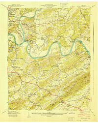
~ Shooks Gap TN topo map, 1:24000 scale, 7.5 X 7.5 Minute, Historical, 1940
Shooks Gap, Tennessee, USGS topographic map dated 1940.
Includes geographic coordinates (latitude and longitude). This topographic map is suitable for hiking, camping, and exploring, or framing it as a wall map.
Printed on-demand using high resolution imagery, on heavy weight and acid free paper, or alternatively on a variety of synthetic materials.
Topos available on paper, Waterproof, Poly, or Tyvek. Usually shipping rolled, unless combined with other folded maps in one order.
- Product Number: USGS-5337472
- Free digital map download (high-resolution, GeoPDF): Shooks Gap, Tennessee (file size: 13 MB)
- Map Size: please refer to the dimensions of the GeoPDF map above
- Weight (paper map): ca. 55 grams
- Map Type: POD USGS Topographic Map
- Map Series: HTMC
- Map Verison: Historical
- Cell ID: 41164
- Scan ID: 153134
- Woodland Tint: Yes
- Field Check Year: 1940
- Datum: NAD27
- Map Projection: Polyconic
- Preliminary map: Yes
- Map published by Tennessee Valley Authority
- Map Language: English
- Scanner Resolution: 600 dpi
- Map Cell Name: Shooks Gap
- Grid size: 7.5 X 7.5 Minute
- Date on map: 1940
- Map Scale: 1:24000
- Geographical region: Tennessee, United States
Neighboring Maps:
All neighboring USGS topo maps are available for sale online at a variety of scales.
Spatial coverage:
Topo map Shooks Gap, Tennessee, covers the geographical area associated the following places:
- Woodfield Park - Shooks Gap - Asbury - Shooks - New Hopewell - Grandview - Hendron - Johnson Road - Seymour Heights - Pitner (historical) - Whites Village - Crossfield - High Bluff - Forks of the River - Moshina Heights - Sevier Home - Lake Forest - Kimberlin Heights - Marbledale - Holston Hills - Neubert - Neubert Springs - Valley Grove - Riverdale - Mule Hollow - Ramsey - Meades Quarry
- Map Area ID: AREA3635.875-83.875-83.75
- Northwest corner Lat/Long code: USGSNW36-83.875
- Northeast corner Lat/Long code: USGSNE36-83.75
- Southwest corner Lat/Long code: USGSSW35.875-83.875
- Southeast corner Lat/Long code: USGSSE35.875-83.75
- Northern map edge Latitude: 36
- Southern map edge Latitude: 35.875
- Western map edge Longitude: -83.875
- Eastern map edge Longitude: -83.75


