
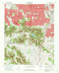
~ Oak Hill TN topo map, 1:24000 scale, 7.5 X 7.5 Minute, Historical, 1968, updated 1971
Oak Hill, Tennessee, USGS topographic map dated 1968.
Includes geographic coordinates (latitude and longitude). This topographic map is suitable for hiking, camping, and exploring, or framing it as a wall map.
Printed on-demand using high resolution imagery, on heavy weight and acid free paper, or alternatively on a variety of synthetic materials.
Topos available on paper, Waterproof, Poly, or Tyvek. Usually shipping rolled, unless combined with other folded maps in one order.
- Product Number: USGS-5336584
- Free digital map download (high-resolution, GeoPDF): Oak Hill, Tennessee (file size: 16 MB)
- Map Size: please refer to the dimensions of the GeoPDF map above
- Weight (paper map): ca. 55 grams
- Map Type: POD USGS Topographic Map
- Map Series: HTMC
- Map Verison: Historical
- Cell ID: 32736
- Scan ID: 149178
- Imprint Year: 1971
- Woodland Tint: Yes
- Aerial Photo Year: 1967
- Field Check Year: 1968
- Datum: NAD27
- Map Projection: Polyconic
- Map published by United States Geological Survey
- Map Language: English
- Scanner Resolution: 600 dpi
- Map Cell Name: Oak Hill
- Grid size: 7.5 X 7.5 Minute
- Date on map: 1968
- Map Scale: 1:24000
- Geographical region: Tennessee, United States
Neighboring Maps:
All neighboring USGS topo maps are available for sale online at a variety of scales.
Spatial coverage:
Topo map Oak Hill, Tennessee, covers the geographical area associated the following places:
- Hidden Valley Estates - Brentwood - Carondelet - Land Mark - Phillips - Crieve Hall - Williamson Estates - Oak Hill - Williamsburg Estates - Heathrow - Beachville (historical) - Battlewood Forest - Country Club Estates - Laurel Wood Estates - Wildwood Estates - Brentwood Station - Oak Hampton - Glendale Park - Forest Hills - Deerwood - Smyrna Road Homes - Benbar - Fountainhead - Meadowlake - Brentwood Park - Belle Meade - Dekemont Downs - Brentwood Estates - Cloverland Acres - Belle Rive - Foxland Hall - Murray Lane Estates - River Oak Estates - Derby Glen - Murray Estates - Green Hills - Oak Hill Estates - Berry Hill - Belle Rive Highlands - Mizell (historical) - Heathrow Hills - Hillview Estates - Cambridge Hills - Iroquois Estates - Forest of Brentwood
- Map Area ID: AREA36.12536-86.875-86.75
- Northwest corner Lat/Long code: USGSNW36.125-86.875
- Northeast corner Lat/Long code: USGSNE36.125-86.75
- Southwest corner Lat/Long code: USGSSW36-86.875
- Southeast corner Lat/Long code: USGSSE36-86.75
- Northern map edge Latitude: 36.125
- Southern map edge Latitude: 36
- Western map edge Longitude: -86.875
- Eastern map edge Longitude: -86.75


