
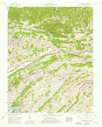
~ Indian Springs TN topo map, 1:24000 scale, 7.5 X 7.5 Minute, Historical, 1959, updated 1976
Indian Springs, Tennessee, USGS topographic map dated 1959.
Includes geographic coordinates (latitude and longitude). This topographic map is suitable for hiking, camping, and exploring, or framing it as a wall map.
Printed on-demand using high resolution imagery, on heavy weight and acid free paper, or alternatively on a variety of synthetic materials.
Topos available on paper, Waterproof, Poly, or Tyvek. Usually shipping rolled, unless combined with other folded maps in one order.
- Product Number: USGS-5335092
- Free digital map download (high-resolution, GeoPDF): Indian Springs, Tennessee (file size: 15 MB)
- Map Size: please refer to the dimensions of the GeoPDF map above
- Weight (paper map): ca. 55 grams
- Map Type: POD USGS Topographic Map
- Map Series: HTMC
- Map Verison: Historical
- Cell ID: 21874
- Scan ID: 147786
- Imprint Year: 1976
- Woodland Tint: Yes
- Photo Revision Year: 1968
- Aerial Photo Year: 1968
- Field Check Year: 1959
- Datum: NAD27
- Map Projection: Polyconic
- Map published by Tennessee Valley Authority
- Map Language: English
- Scanner Resolution: 600 dpi
- Map Cell Name: Indian Springs
- Grid size: 7.5 X 7.5 Minute
- Date on map: 1959
- Map Scale: 1:24000
- Geographical region: Tennessee, United States
Neighboring Maps:
All neighboring USGS topo maps are available for sale online at a variety of scales.
Spatial coverage:
Topo map Indian Springs, Tennessee, covers the geographical area associated the following places:
- Hillcrest - Fall Creek - Kingsley Hills - Preston Woods - Bridwell Heights - Lake Park - Ketrontown - Bloomingdale - Scenic Woods - Hobart Meadows - Beechcliff Estates - Indian Hills - Brairwood Acres - Edgeworth (historical) - Woodrow - Harrtown - Sunrise Valley - Lawson (historical) - Mystic Valley - Gunnings - Orebank - Holiday Hills - Rock City - Huddle Mill - Sunnyside - Fox Fire - Arcadia - Silvacola - Pettyjohn Mill - Hemlock - Thomas Heights
- Map Area ID: AREA36.62536.5-82.5-82.375
- Northwest corner Lat/Long code: USGSNW36.625-82.5
- Northeast corner Lat/Long code: USGSNE36.625-82.375
- Southwest corner Lat/Long code: USGSSW36.5-82.5
- Southeast corner Lat/Long code: USGSSE36.5-82.375
- Northern map edge Latitude: 36.625
- Southern map edge Latitude: 36.5
- Western map edge Longitude: -82.5
- Eastern map edge Longitude: -82.375


