
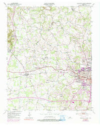
~ Cookeville West TN topo map, 1:24000 scale, 7.5 X 7.5 Minute, Historical, 1953, updated 1990
Cookeville West, Tennessee, USGS topographic map dated 1953.
Includes geographic coordinates (latitude and longitude). This topographic map is suitable for hiking, camping, and exploring, or framing it as a wall map.
Printed on-demand using high resolution imagery, on heavy weight and acid free paper, or alternatively on a variety of synthetic materials.
Topos available on paper, Waterproof, Poly, or Tyvek. Usually shipping rolled, unless combined with other folded maps in one order.
- Product Number: USGS-5333630
- Free digital map download (high-resolution, GeoPDF): Cookeville West, Tennessee (file size: 11 MB)
- Map Size: please refer to the dimensions of the GeoPDF map above
- Weight (paper map): ca. 55 grams
- Map Type: POD USGS Topographic Map
- Map Series: HTMC
- Map Verison: Historical
- Cell ID: 9944
- Scan ID: 143853
- Imprint Year: 1990
- Woodland Tint: Yes
- Visual Version Number: 1
- Photo Inspection Year: 1981
- Photo Revision Year: 1974
- Aerial Photo Year: 1974
- Field Check Year: 1953
- Datum: NAD27
- Map Projection: Polyconic
- Map published by United States Geological Survey
- Map Language: English
- Scanner Resolution: 600 dpi
- Map Cell Name: Cookeville West
- Grid size: 7.5 X 7.5 Minute
- Date on map: 1953
- Map Scale: 1:24000
- Geographical region: Tennessee, United States
Neighboring Maps:
All neighboring USGS topo maps are available for sale online at a variety of scales.
Spatial coverage:
Topo map Cookeville West, Tennessee, covers the geographical area associated the following places:
- Green Hills - Cookeville - Grandiose Field - College Heights - Sherwood Estates - Oakdale - Rolling Meadows - Springdale - Petite Subdivision - Harley Subdivision - Shiloh - Colonial Acres - Apple Valley Estates - Holladay - Ashcroft Subdivision - Sun Valley - Rose Garden Estates - Pippen Springs Estates - Oakland - Deberry Heights - Marie White Subdivision - Blackburn Hills Estates - Mount Vernon - Tanglewood - Snow Mayberry Subdivision - Wildwood - Green Acres - Tara Estates - Quality Estates - Ensor Park - McCrary Subdivision - Bloomington Springs - Speck Subdivision - Double Springs - Forest Hills - Honeybrook - Shepherd Hills - Brandywine Estates - Bill Smith Subdivision - Melrose - Hillsdale - Long Meadows - Westgate
- Map Area ID: AREA36.2536.125-85.625-85.5
- Northwest corner Lat/Long code: USGSNW36.25-85.625
- Northeast corner Lat/Long code: USGSNE36.25-85.5
- Southwest corner Lat/Long code: USGSSW36.125-85.625
- Southeast corner Lat/Long code: USGSSE36.125-85.5
- Northern map edge Latitude: 36.25
- Southern map edge Latitude: 36.125
- Western map edge Longitude: -85.625
- Eastern map edge Longitude: -85.5


