
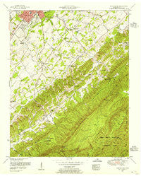
~ Blockhouse TN topo map, 1:24000 scale, 7.5 X 7.5 Minute, Historical, 1953, updated 1956
Blockhouse, Tennessee, USGS topographic map dated 1953.
Includes geographic coordinates (latitude and longitude). This topographic map is suitable for hiking, camping, and exploring, or framing it as a wall map.
Printed on-demand using high resolution imagery, on heavy weight and acid free paper, or alternatively on a variety of synthetic materials.
Topos available on paper, Waterproof, Poly, or Tyvek. Usually shipping rolled, unless combined with other folded maps in one order.
- Product Number: USGS-5332746
- Free digital map download (high-resolution, GeoPDF): Blockhouse, Tennessee (file size: 15 MB)
- Map Size: please refer to the dimensions of the GeoPDF map above
- Weight (paper map): ca. 55 grams
- Map Type: POD USGS Topographic Map
- Map Series: HTMC
- Map Verison: Historical
- Cell ID: 4402
- Scan ID: 149502
- Imprint Year: 1956
- Woodland Tint: Yes
- Aerial Photo Year: 1952
- Field Check Year: 1953
- Datum: NAD27
- Map Projection: Polyconic
- Map published by Tennessee Valley Authority
- Map Language: English
- Scanner Resolution: 600 dpi
- Map Cell Name: Blockhouse
- Grid size: 7.5 X 7.5 Minute
- Date on map: 1953
- Map Scale: 1:24000
- Geographical region: Tennessee, United States
Neighboring Maps:
All neighboring USGS topo maps are available for sale online at a variety of scales.
Spatial coverage:
Topo map Blockhouse, Tennessee, covers the geographical area associated the following places:
- Sunset View - Highland Acres - Creekwood - Montvale - Sherwood Forest - Forest Hill - Oaklawn Addition - Law Chapel - East Forest - Lonas Addition - Oxford Hills - College Park Estates - Chelsey Village - Sixmile - Willard Addition - Briarcliff - Eastover - Buena Vista - Windsor Park - Wimbledon - Belle Meade - Tee Lee Heights - South View Estates - Turnberry Vistas - Blockhouse - Heritage Hills - Montvale Springs - Montvue - Chilhowee View - Westwood Hills - Mountain View Addition
- Map Area ID: AREA35.7535.625-84-83.875
- Northwest corner Lat/Long code: USGSNW35.75-84
- Northeast corner Lat/Long code: USGSNE35.75-83.875
- Southwest corner Lat/Long code: USGSSW35.625-84
- Southeast corner Lat/Long code: USGSSE35.625-83.875
- Northern map edge Latitude: 35.75
- Southern map edge Latitude: 35.625
- Western map edge Longitude: -84
- Eastern map edge Longitude: -83.875


