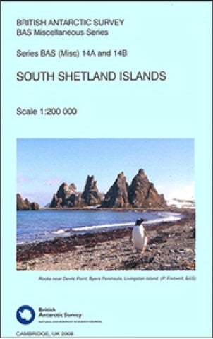
South Shetland Islands by British Antarctic Survey
This is an impressive topographic and bathymetric overview map of the South Shetland Islands. This double-sided sheet is split into three smaller maps - Livingston Island (including Smith, Low & Deception Islands) on one side, around Elephant Island and around King George Island on the reverse side. The map data is from satellite data, and is not for navigational use. It is, however, a beautiful and informative overview of these remote islands. The map uses satellite imagery as its base, making it a visually stunning map.
- Product Number: 2216989M
- Product Code: BAS_S_SHETLAND
- ISBN: 9780856651441
- Year of Publication: 2008
- Folded Size: 8.27 x 5.12 inches
- Unfolded Size: 30.31 x 38.98 inches
- Map type: Folded Map
- Geographical region: Antarctica