
Tennessee, Physical Wall Map by Raven Maps
Detailed physical wall map of Tennessee State at a scale of 1:500,000.
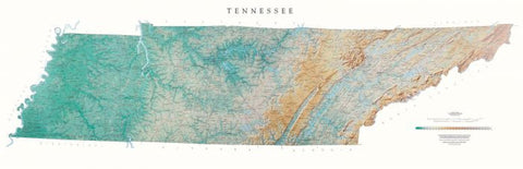
The cartography shows relief through a stunning, highly detailed shading, with different elevations varying in color, giving an almost 3-dimensional feel to the map. Peak heights are also clearly marked.
The map displays land only within the boundaries of the state - there is no overlap with neighboring states. Principal physical features such as glaciers, mountain ranges, rivers and lakes are shown clearly. Human features, such as main towns, cities, roads and railways, are shown in a very fine, subtle and elegant cartographic style. State capitals are also clearly marked.
This map measures 54 x 166cm (21 x 65). Tennessee extends from the Bottoms along the Mississippi River, through the rich farming country of the Nashville Basin, the Cumberland Plateau and The Great Valley, all the way to the beautiful Great Smoky Mountains in the east. From Lookout Mountain on the Plateau, you can see seven states.
- Product Number: 2066727M
- Product Code: RP_TN_WA
- ISBN: 9780783425870
- Year of Publication: 1997
- Map type: Wall Map
- Geographical region: Tennessee


