
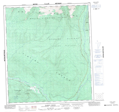
116B02 Rabbit Creek Canada topo map, 1:50,000 scale
116B02 Rabbit Creek NRCAN topographic map.
Includes UTM and GPS geographic coordinates (latitude and longitude). This 50k scale map is suitable for hiking, camping, and exploring, or you could frame it as a wall map.
Printed on-demand using high resolution, on heavy weight and acid free paper, or as an upgrade on a variety of synthetic materials.
Topos available on paper, Waterproof, Poly, or Tyvek. Usually shipping rolled, unless combined with other folded maps in one order.
- Product Number: NRCAN-116B02
- Parent Topo: TOPO-116B
- Map ID also known as: 116B02, 116B2
- Unfolded Size: Approximately 26" high by 36" wide
- Weight (paper map): ca. 55 grams
- Map Type: POD NRCAN Topographic Map
- Map Scale: 1:50,000
- Geographical region: Yukon, Canada
Neighboring Maps:
All neighboring Canadian topo maps are available for sale online at 1:50,000 scale.
Purchase the smaller scale map covering this area: Topo-116B
Spatial coverage:
Topo map sheet 116B02 Rabbit Creek covers the following places:
- Big Lake - Mischenko Lakes - Tom O'Hara Lake - North Klondike Range - Ogilvie Mountains - Ogilvie Range - Signal Hill - Snowy Range - Klondike Plateau - Stewart Plateau - Yukon Plateau - Alki Creek - Antimony Creek - Benson Creek - Coal Creek - Dognose Creek - Dognose Creek - Fish Creek - Germaine Creek - Gilcher Creek - Goring Creek - Hollenbeck Creek - Jeckell Creek - Klondike River - Leroy Creek - Linta Creek - Morrison Creek - Nordling Creek - North Fork of Klondike River - North Klondike River - Rabbit Creek - Rock Creek - Tintina Trench - Tintina Valley


