
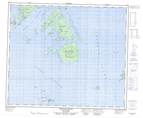
103J07 Melville Island Canada topo map, 1:50,000 scale
103J07 Melville Island NRCAN topographic map.
Includes UTM and GPS geographic coordinates (latitude and longitude). This 50k scale map is suitable for hiking, camping, and exploring, or you could frame it as a wall map.
Printed on-demand using high resolution, on heavy weight and acid free paper, or as an upgrade on a variety of synthetic materials.
Topos available on paper, Waterproof, Poly, or Tyvek. Usually shipping rolled, unless combined with other folded maps in one order.
- Product Number: NRCAN-103J07
- Parent Topo: TOPO-103J
- Map ID also known as: 103J07, 103J7
- Unfolded Size: Approximately 26" high by 36" wide
- Weight (paper map): ca. 55 grams
- Map Type: POD NRCAN Topographic Map
- Map Scale: 1:50,000
- Geographical region: British Columbia, Canada
Neighboring Maps:
All neighboring Canadian topo maps are available for sale online at 1:50,000 scale.
Purchase the smaller scale map covering this area: Topo-103J
Spatial coverage:
Topo map sheet 103J07 Melville Island covers the following places:
- Chatham Sound - Clam Inlet - Edith Harbour - Chapman Point - Dawes Point - Deans Point - Farwest Point - Gore-Langton Point - Jackal Point - Brown Passage - Hudson Bay Passage - Dundas Island Indian Reserve 32B - Far West Point Indian Reserve 34 - Prince Leboo Island Indian Reserve 32 - Réserve indienne Dundas Island 32B - Réserve indienne Far West Point 34 - Réserve indienne Prince Leboo Island 32 - Réserve indienne Rushton Island 90 - Réserve indienne Tugwell Island 21 - Rushton Island Indian Reserve 90 - Tugwell Island Indian Reserve 21 - Baron Island - Chearnley Island - Chearnley Islet - Connel Islands - Dundas Island - Dundas Islands - Dunira Island - Lucy Islands - Melville Island - Moffatt Islands - Nares Islets - Osborne Islands - Prince Leboo Island - Randall Island - Rushton Island - Tree Nob Group - Triple Islands - Triple Islets - Tugwell Island - Coast Mound - Kitimat Ranges - Knee Hill - Beaver Rock - Coghlan Rock - Cutter Rock - Dawes Rock - Dawes Rocks - Egeria Rock - Enfield Rock - Hammond Rocks - Hanmer Rocks - Hodgson Reefs - Moore Shoal - Simpson Rock - Stenhouse Shoal - Taylor Rock - Tugwell Reef


