
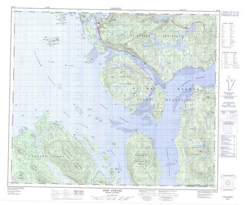
103J01 Port Edward Canada topo map, 1:50,000 scale
103J01 Port Edward NRCAN topographic map.
Includes UTM and GPS geographic coordinates (latitude and longitude). This 50k scale map is suitable for hiking, camping, and exploring, or you could frame it as a wall map.
Printed on-demand using high resolution, on heavy weight and acid free paper, or as an upgrade on a variety of synthetic materials.
Topos available on paper, Waterproof, Poly, or Tyvek. Usually shipping rolled, unless combined with other folded maps in one order.
- Product Number: NRCAN-103J01
- Parent Topo: TOPO-103J
- Map ID also known as: 103J01, 103J1
- Unfolded Size: Approximately 26" high by 36" wide
- Weight (paper map): ca. 55 grams
- Map Type: POD NRCAN Topographic Map
- Map Scale: 1:50,000
- Geographical region: British Columbia, Canada
Neighboring Maps:
All neighboring Canadian topo maps are available for sale online at 1:50,000 scale.
Purchase the smaller scale map covering this area: Topo-103J
Spatial coverage:
Topo map sheet 103J01 Port Edward covers the following places:
- Chalmers Anchorage - Chatham Sound - Humpback Bay - Hunt Inlet - Jap Inlet - Kloiya Bay - Lawson Harbour - Moore Cove - Porpoise Harbour - Tremayne Bay - Tsum Tsadai Inlet - Wainwright Basin - Clara Point - Clough Point - Cocktail Point - Creak Point - Francis Point - Fraser Point - Gamble Point - Georgy Point - Godfrey Point - Gust Point - Hanmer Point - Hazel Point - Hegan Point - Hicks Point - Hunt Point - Inrig Point - Island Point - Lamb Point - Lambert Point - Leer Point - Lima Point - Mason Point - Moore Point - Mowitch Point - Osborn Point - Parry Point - Soar Point - Tatenham Point - Tsimpsean Peninsula - Veitch Point - Arthur Passage - Bloxam Passage - Chismore Passage - De Horsey Passage - Eleanor Passage - Inverness Passage - Kelp Passage - Malacca Passage - Marcus Passage - Porpoise Channel - Telegraph Passage - Marked Tree Bluff - Port Edward - Dashken Indian Reserve 22 - Kshaoom Indian Reserve 23 - Meanlaw Indian Reserve 24 - Réserve indienne Dashken 22 - Réserve indienne Kshaoom 23 - Réserve indienne Meanlaw 24 - Ada Islands - Alice Island - Bamfield Islands - Bishop Island - Break Island - Bribery Island - Bribery Islet - Coast Island - Creak Islands - Croasdaile Island - De Horsey Island - Digby Island - East Kinahan Island - Elliott Island - Gay Island - Genn Islands - Grace Island - Greentop Islet - Hanmer Island - Kaien Island - Kennedy Island - Kinahan Islands - Kitson Island - Kitson Islet - Lamppost Islet - Lawyer Islands - Lelu Island - Lewis Island - Little Genn Island - Little Kinahan Island - McMicking Island - Metford Island - Neill Islet - Orwig Islets - Porcher Island - Ridley Island - Smith Island - South Kinahan Island - Spire Island - Stapledon Island - Tuck Island - West Kinahan Island - Alwyn Lake - Artificial Lake - Balagno Lake - Blain Lake - Bremner Lake - Carlisle Lake - Colonel Johnston Lake - Diana Lake - Emergency Lake - Fortune Lake - Harrison Lake - Icy Lake - Macmillan Lake - Peck Lake - Porpoise Lake - Prudhomme Lake - Prud'homme Lake - Ptarmigan Lake - Rainbow Lake - Salt Lagoon - Salt Lake - Taylor Lake - Useless Lake - Bell Range - Chismore Range - Coast Mountains - Cunningham Peak - Elizabeth Peak - Kitimat Ranges - Morrison Mountain - Mount Chapleau - Mount Dodge - Mount McDonald - Mount McGrath - Mount Morrison - Mount Steckel - Mount Stewart - Spiller Range - Spruce Hill - Diana Lake Park - Kitson Island Marine Park - Prudhomme Lake Park - Back Creek - Beaver River - Boneyard Creek - Canyon Creek - Carlisle Creek - Caspaco Creek - Claxton Creek - Colonel Johnston Creek - Foote Creek - Gamble Creek - Haysport Creek - Humpback Creek - Kildala Creek - Kloiya River - MacMillan Creek - Porcher Creek - Skeena River - Spiller River - Standard Creek - Useless Creek - Wolf Creek - Zanardi Rapids - Agnew Bank - Bacon Rock - Barrett Rock - Base - Base Sand - Brooks Rock - Cecil Patch - Chassepot Rock - Clara Shoal - Client Reefs - Colquhoun Shoal - Cruice Rock - Davies Bank - Dor Rock - Ellinor Rock - Ettrick Rock - Falcon Rock - Flora Bank - Georgia Rock - Grace Rock - Havelock Rock - Herbert Reefs - Holland Rock - Horsey Bank - Kestrel Rock - Marion Rock - Mathews Rock - Petrel Rock - Robertson Banks - Spire Ledge - Tsum Tsadai Rock - Veitch Rock - Billmor - Carlisle - Caspaco - Caspaco Cannery - Cassiar - Claxton - Haysport - Hunts Inlet - Inverness - Jap Inlet - Kaien - Lewis Island - North Pacific - Oceanic - Osland - Phelan - Porcher Island - Ridley - Sockeye - Sunnyside - Watson Island - Rainbow Pass


