
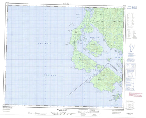
103G15 Kitkatla Inlet Canada topo map, 1:50,000 scale
103G15 Kitkatla Inlet NRCAN topographic map.
Includes UTM and GPS geographic coordinates (latitude and longitude). This 50k scale map is suitable for hiking, camping, and exploring, or you could frame it as a wall map.
Printed on-demand using high resolution, on heavy weight and acid free paper, or as an upgrade on a variety of synthetic materials.
Topos available on paper, Waterproof, Poly, or Tyvek. Usually shipping rolled, unless combined with other folded maps in one order.
- Product Number: NRCAN-103G15
- Parent Topo: TOPO-103G
- Map ID also known as: 103G15
- Unfolded Size: Approximately 26" high by 36" wide
- Weight (paper map): ca. 55 grams
- Map Type: POD NRCAN Topographic Map
- Map Scale: 1:50,000
- Geographical region: British Columbia, Canada
Neighboring Maps:
All neighboring Canadian topo maps are available for sale online at 1:50,000 scale.
Purchase the smaller scale map covering this area: Topo-103G
Spatial coverage:
Topo map sheet 103G15 Kitkatla Inlet covers the following places:
- Dries Inlet - Gurd Inlet - Kitkatla Inlet - Kitkatlah Inlet - Kitkatlah Inlet - North Arm Kitkatlah Inlet - Oval Bay - Porcher Inlet - Serpentine Inlet - Welcome Harbour - Willis Bay - Cape George - Chief Point - Fan Point - Goschen Point - Goschen Spit - Gurd Point - Joachim Point - Joachim Spit - Nubble Point - Oval Point - Porcher Peninsula - Snass Point - Viscount Point - Whiteley Point - Browning Entrance - Freeman Passage - Hecate Strait - Kitkatla Channel - Absalom Island - Cessford Islands - Clamshell Island - Coquitlam Island - Dancey Island - Fan Island - Goschen Island - Gurd Island - Moore Island - Ness Islands - Phoenix Islands - Porcher Island - Prager Islands - Robert Island - Shakes Islands - Snass Islands - Wilcox Group - Bell Range - False Cone - Flat Hill - Mount Nubble - Nubble Mountain - Oval Hill - Regional District of Kitimat-Stikine - Camp Creek - Canyon Creek - Kitkalah Creek - Kitkatla Creek - Phoenix Creek - Porcher Creek - Barren Rocks - Bass Rock - Hall Rock - Joachim Rock - Oval Bank - Oval Rock - Ste. Croix Rock - Theresa Rock - Winter Rock


