
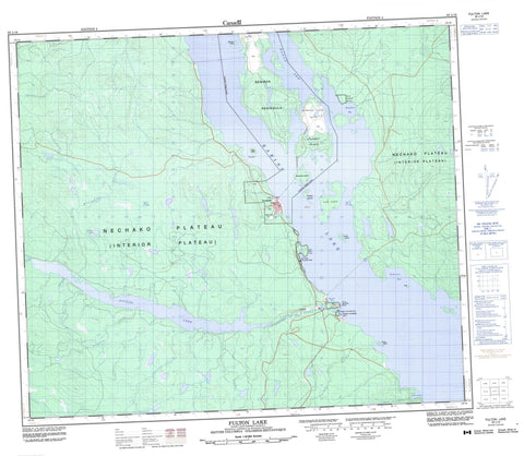
093L16 Fulton Lake Canada topo map, 1:50,000 scale
093L16 Fulton Lake NRCAN topographic map.
Includes UTM and GPS geographic coordinates (latitude and longitude). This 50k scale map is suitable for hiking, camping, and exploring, or you could frame it as a wall map.
Printed on-demand using high resolution, on heavy weight and acid free paper, or as an upgrade on a variety of synthetic materials.
Topos available on paper, Waterproof, Poly, or Tyvek. Usually shipping rolled, unless combined with other folded maps in one order.
- Product Number: NRCAN-093L16
- Parent Topo: TOPO-093L
- Map ID also known as: 093L16, 93L16
- Unfolded Size: Approximately 26" high by 36" wide
- Weight (paper map): ca. 55 grams
- Map Type: POD NRCAN Topographic Map
- Map Scale: 1:50,000
- Geographical region: British Columbia, Canada
Neighboring Maps:
All neighboring Canadian topo maps are available for sale online at 1:50,000 scale.
Purchase the smaller scale map covering this area: Topo-093L
Spatial coverage:
Topo map sheet 093L16 Fulton Lake covers the following places:
- Hagan Arm - Hawthorn Bay - Michell Bay - Nose Bay - Port Arthur - Wilkinson Bay - Newman Peninsula - Red Bluff Point - Babine Indian Reserve 25 - Babine Indian Reserve 26 - Réserve indienne Babine 25 - Réserve indienne Babine 26 - Bear Island - Double Island - Gopher Islands - Long Island - McDonald Island - Newman Island - Red Island - Snowshoe Island - Sterrett Island - Tachek Island - The Cub - Babine Lake - Fulton Lake - Saturday Lake - Timber Lake - Regional District of Bulkley-Nechako - Red Bluff Park - Topley Landing Park - Topley Park - Interior Plateau - Nechako Plateau - Broughton Creek - Deasy Creek - Eggleston Creek - Fulton River - Guess Creek - Maidment Creek - Nicholson Creek - Tachek Creek - Tanglechain Creek - Topley Landing - Granisle


