
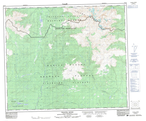
093L06 Thautil River Canada topo map, 1:50,000 scale
093L06 Thautil River NRCAN topographic map.
Includes UTM and GPS geographic coordinates (latitude and longitude). This 50k scale map is suitable for hiking, camping, and exploring, or you could frame it as a wall map.
Printed on-demand using high resolution, on heavy weight and acid free paper, or as an upgrade on a variety of synthetic materials.
Topos available on paper, Waterproof, Poly, or Tyvek. Usually shipping rolled, unless combined with other folded maps in one order.
- Product Number: NRCAN-093L06
- Parent Topo: TOPO-093L
- Map ID also known as: 093L06, 93L6, 93L06
- Unfolded Size: Approximately 26" high by 36" wide
- Weight (paper map): ca. 55 grams
- Map Type: POD NRCAN Topographic Map
- Map Scale: 1:50,000
- Geographical region: British Columbia, Canada
Neighboring Maps:
All neighboring Canadian topo maps are available for sale online at 1:50,000 scale.
Purchase the smaller scale map covering this area: Topo-093L
Spatial coverage:
Topo map sheet 093L06 Thautil River covers the following places:
- Holland Lakes - Melissen Lake - Mooseskin Johnny Lake - Bulkley Ranges - Telkwa Range - Regional District of Bulkley-Nechako - Regional District of Kitimat-Stikine - Interior Plateau - Nechako Plateau - Denys Creek - Dockrill Creek - Emerson Creek - Evening Creek - Gabriel Creek - Glacis Creek - Hagman Creek - Houston Tommy Creek - Howson Creek - Loljuh Creek - Lukens Creek - Mooseskin Creek - Scallon Creek - Shea Creek - Starr Creek - Tagit Creek - Thautil River


