
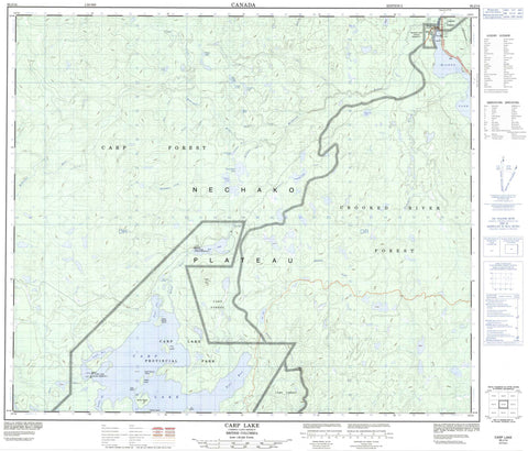
093J14 Carp Lake Canada topo map, 1:50,000 scale
093J14 Carp Lake NRCAN topographic map.
Includes UTM and GPS geographic coordinates (latitude and longitude). This 50k scale map is suitable for hiking, camping, and exploring, or you could frame it as a wall map.
Printed on-demand using high resolution, on heavy weight and acid free paper, or as an upgrade on a variety of synthetic materials.
Topos available on paper, Waterproof, Poly, or Tyvek. Usually shipping rolled, unless combined with other folded maps in one order.
- Product Number: NRCAN-093J14
- Parent Topo: TOPO-093J
- Map ID also known as: 093J14, 93J14
- Unfolded Size: Approximately 26" high by 36" wide
- Weight (paper map): ca. 55 grams
- Map Type: POD NRCAN Topographic Map
- Map Scale: 1:50,000
- Geographical region: British Columbia, Canada
Neighboring Maps:
All neighboring Canadian topo maps are available for sale online at 1:50,000 scale.
Purchase the smaller scale map covering this area: Topo-093J
Spatial coverage:
Topo map sheet 093J14 Carp Lake covers the following places:
- Drumlin Bay - Kettle Bay - Sekani Bay - Till Bay - War Falls - Blue Lake 24 - Carp Lake Indian Reserve 3 - McLeod Lake Indian Reserve 1 - Réserve indienne Carp Lake 3 - Réserve indienne McLeod Lake 1 - Réserve indienne War Lake 4 - War Lake Indian Reserve 4 - Weedon Carp 6 - Alder Island - Aspen Island - Birch Island - Black Spruce Island - Fir Island - Pine Island - Spirea Island - White Spruce Island - Ant Lake - Blue Lake - Bonnington Lake - Boot Jack Lake - Carp Lake - Fluff Lake - Garnetred Lake - Iroquois Lake - Loch Lang - McLeod Lake - Minnow Lake - Monk Lake - Munlo Lake - Rainbow Lake - Sekani Lake - Snowshoe Lake - Swamp Grass Lake - War Lake - Warhorse Lake - Whisper Lake - Windy Lake - Ant Hill - Carp Hill - Regional District of Bulkley-Nechako - Regional District of Fraser-Fort George - Carp Lake Park - Fort McLeod Historic Park - Interior Plateau - Nechako Plateau - Bonnington Creek - Des Creek - Garnetred Creek - Hammett Creek - Holder Creek - Iroquois Creek - McDougall River - McLeod River - Moffatt Creek - Pack River - Pan Creek - Pelton Creek - Pyrite Creek - Reed Creek - Rocker Creek - Fort McLeod - McLeod Lake


