
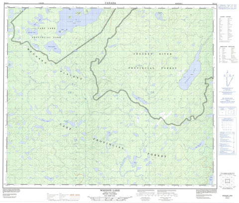
093J11 Weedon Lake Canada topo map, 1:50,000 scale
093J11 Weedon Lake NRCAN topographic map.
Includes UTM and GPS geographic coordinates (latitude and longitude). This 50k scale map is suitable for hiking, camping, and exploring, or you could frame it as a wall map.
Printed on-demand using high resolution, on heavy weight and acid free paper, or as an upgrade on a variety of synthetic materials.
Topos available on paper, Waterproof, Poly, or Tyvek. Usually shipping rolled, unless combined with other folded maps in one order.
- Product Number: NRCAN-093J11
- Parent Topo: TOPO-093J
- Map ID also known as: 093J11, 93J11
- Unfolded Size: Approximately 26" high by 36" wide
- Weight (paper map): ca. 55 grams
- Map Type: POD NRCAN Topographic Map
- Map Scale: 1:50,000
- Geographical region: British Columbia, Canada
Neighboring Maps:
All neighboring Canadian topo maps are available for sale online at 1:50,000 scale.
Purchase the smaller scale map covering this area: Topo-093J
Spatial coverage:
Topo map sheet 093J11 Weedon Lake covers the following places:
- Drumlin Bay - Esker Bay - Weedon Lake 27 - Cedar Island - Cottonwood Island - Fir Island - Spirea Island - Willow Island - Carp Lake - Dace Lake - Gates Lake - Gilgan Lake - Hammett Lake - Joanne Lake - Kaminski Lake - Lho Lakes - Merton Lake - Oop Lake - Shiner Lake - Squawfish Lake - Sucker Lake - Tyee Lake - Weedon Lake - Whusnatsidzih Lake - Regional District of Fraser-Fort George - Carp Lake Park - Interior Plateau - Nechako Plateau - Joanne Creek - Kaminski Creek - McLeod River - Muskeg River - Weedon Creek


