
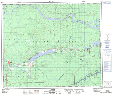
093J01 Giscome Canada topo map, 1:50,000 scale
093J01 Giscome NRCAN topographic map.
Includes UTM and GPS geographic coordinates (latitude and longitude). This 50k scale map is suitable for hiking, camping, and exploring, or you could frame it as a wall map.
Printed on-demand using high resolution, on heavy weight and acid free paper, or as an upgrade on a variety of synthetic materials.
Topos available on paper, Waterproof, Poly, or Tyvek. Usually shipping rolled, unless combined with other folded maps in one order.
- Product Number: NRCAN-093J01
- Parent Topo: TOPO-093J
- Map ID also known as: 093J01, 93J1, 93J01
- Unfolded Size: Approximately 26" high by 36" wide
- Weight (paper map): ca. 55 grams
- Map Type: POD NRCAN Topographic Map
- Map Scale: 1:50,000
- Geographical region: British Columbia, Canada
Neighboring Maps:
All neighboring Canadian topo maps are available for sale online at 1:50,000 scale.
Purchase the smaller scale map covering this area: Topo-093J
Spatial coverage:
Topo map sheet 093J01 Giscome covers the following places:
- Aleza Lake - Burned Lake - Eaglet Lake - Hansard Lake - Nazul Lake - Tshil Lake - Regional District of Fraser-Fort George - Interior Plateau - Nechako Plateau - Antonson Creek - Averil Creek - Bateman Creek - Bearman Creek - Beaver Creek - Bowron River - Charlie Creek - Fraser River - Hay Creek - Herring Creek - Hospital Creek - Jacura Creek - Jules Creek - Kerry Creek - Limestone Creek - Mann Creek - McGregor River - Mokus Creek - Ogilvie Creek - Olsson Creek - Slaney Creek - Tay Creek - Willow River - Aleza Lake - Giscome - Newlands - Newlands Station - Willow City (Willow River P.O.-B. de p.) - Willow River - Wolverine


