
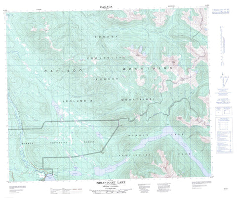
093H06 Indianpoint Lake Canada topo map, 1:50,000 scale
093H06 Indianpoint Lake NRCAN topographic map.
Includes UTM and GPS geographic coordinates (latitude and longitude). This 50k scale map is suitable for hiking, camping, and exploring, or you could frame it as a wall map.
Printed on-demand using high resolution, on heavy weight and acid free paper, or as an upgrade on a variety of synthetic materials.
Topos available on paper, Waterproof, Poly, or Tyvek. Usually shipping rolled, unless combined with other folded maps in one order.
- Product Number: NRCAN-093H06
- Parent Topo: TOPO-093H
- Map ID also known as: 093H06, 93H6, 93H06
- Unfolded Size: Approximately 26" high by 36" wide
- Weight (paper map): ca. 55 grams
- Map Type: POD NRCAN Topographic Map
- Map Scale: 1:50,000
- Geographical region: British Columbia, Canada
Neighboring Maps:
All neighboring Canadian topo maps are available for sale online at 1:50,000 scale.
Purchase the smaller scale map covering this area: Topo-093H
Spatial coverage:
Topo map sheet 093H06 Indianpoint Lake covers the following places:
- Wolverine Bay - Bowron Lake - Clear Mountain Lakes - Indian Lake - Indianpoint Lake - Isaac Lake - Kibbee Lake - Kibee Lakes - Kruger Lake - Thompson Lake - Cariboo Mountains - Caribou Mountain - Clear Mountain - Columbia Mountains - McCabe Ridge - Mount Cochran - Mount Cushman - Mount Kruger - Mount Peever - Quesnel Highland - Wolverine Mountain - Cariboo Regional District - Regional District of Fraser-Fort George - Bowron Lake Park - Fraser Plateau - Interior Plateau - Antler Creek - Bowron River - Brierly Creek - Craze Creek - Dominion Creek - Haggen Creek - Indianpoint Creek - Isaac River - Istsi Creek - Ketcham Creek - Kibbee Creek - Kruger Creek - Littlefield Creek - Macleod Creek - McCabe Creek - McKitrick Creek - Moxley Creek - Nigoo Creek - Rockbed Creek - Sootheran Creek - Summit Creek - Top Creek - Towkuh Creek - Trout Creek - West Creek - Wolverine Creek - Wolverine River - Sentinel Rock


