
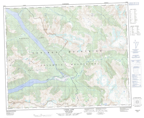
093H02 Lanezi Lake Canada topo map, 1:50,000 scale
093H02 Lanezi Lake NRCAN topographic map.
Includes UTM and GPS geographic coordinates (latitude and longitude). This 50k scale map is suitable for hiking, camping, and exploring, or you could frame it as a wall map.
Printed on-demand using high resolution, on heavy weight and acid free paper, or as an upgrade on a variety of synthetic materials.
Topos available on paper, Waterproof, Poly, or Tyvek. Usually shipping rolled, unless combined with other folded maps in one order.
- Product Number: NRCAN-093H02
- Parent Topo: TOPO-093H
- Map ID also known as: 093H02, 93H2, 93H02
- Unfolded Size: Approximately 26" high by 36" wide
- Weight (paper map): ca. 55 grams
- Map Type: POD NRCAN Topographic Map
- Map Scale: 1:50,000
- Geographical region: British Columbia, Canada
Neighboring Maps:
All neighboring Canadian topo maps are available for sale online at 1:50,000 scale.
Purchase the smaller scale map covering this area: Topo-093H
Spatial coverage:
Topo map sheet 093H02 Lanezi Lake covers the following places:
- Isaac Falls - Isaac Lake - Lanezi Lake - McLeary Lake - Bryan Peak - Cariboo Mountains - Columbia Mountains - Ishpa Mountain - Mount Amos Bowman - Mount Foreman - Mowdish Group - Mowdish Range - Needle Point Ridge - Cariboo Regional District - Regional District of Fraser-Fort George - Bowron Lake Park - Betty Wendle Creek - Bowman Creek - Bowron River - Cariboo River - Harold Creek - Huckey Creek - Isaac River - Kilakuai Creek - Milk River - Turner Creek - Turner River


