
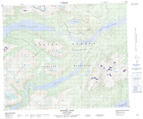
093E11 Troitsa Lake Canada topo map, 1:50,000 scale
093E11 Troitsa Lake NRCAN topographic map.
Includes UTM and GPS geographic coordinates (latitude and longitude). This 50k scale map is suitable for hiking, camping, and exploring, or you could frame it as a wall map.
Printed on-demand using high resolution, on heavy weight and acid free paper, or as an upgrade on a variety of synthetic materials.
Topos available on paper, Waterproof, Poly, or Tyvek. Usually shipping rolled, unless combined with other folded maps in one order.
- Product Number: NRCAN-093E11
- Parent Topo: TOPO-093E
- Map ID also known as: 093E11, 93E11
- Unfolded Size: Approximately 26" high by 36" wide
- Weight (paper map): ca. 55 grams
- Map Type: POD NRCAN Topographic Map
- Map Scale: 1:50,000
- Geographical region: British Columbia, Canada
Neighboring Maps:
All neighboring Canadian topo maps are available for sale online at 1:50,000 scale.
Purchase the smaller scale map covering this area: Topo-093E
Spatial coverage:
Topo map sheet 093E11 Troitsa Lake covers the following places:
- Cummins Point - Rhine Crag - Blanket Lakes - Nechako Reservoir - Seel Lake - Sweeney Lake - Tahtsa Lake - Troitsa Lake - Whitesail Lake - Chaîne Côtière - Coast Mountains - Hazelton Mountains - Huckleberry Mountain - Kasalka Butte - Kasalka Mountains - Kasalka Range - Kitimat Ranges - Laventie Mountain - Mount Baptiste - Mount Bolom - Mount Carl Borden - Rhine Ridge - Sibola Mountains - Sibola Range - Swing Peak - Tahtsa Ranges - Troitsa Peak - Whitesail Range - Regional District of Bulkley-Nechako - Regional District of Kitimat-Stikine - Coles Creek - Comb Creek - Cummins Creek - Kasalka Creek - Rhine Creek - Sibola Creek - Tahtsa River - Troitsa Creek - Whiting Creek - Tahtsa Reach


