
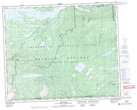
093E01 Oppy Lake Canada topo map, 1:50,000 scale
093E01 Oppy Lake NRCAN topographic map.
Includes UTM and GPS geographic coordinates (latitude and longitude). This 50k scale map is suitable for hiking, camping, and exploring, or you could frame it as a wall map.
Printed on-demand using high resolution, on heavy weight and acid free paper, or as an upgrade on a variety of synthetic materials.
Topos available on paper, Waterproof, Poly, or Tyvek. Usually shipping rolled, unless combined with other folded maps in one order.
- Product Number: NRCAN-093E01
- Parent Topo: TOPO-093E
- Map ID also known as: 093E01, 93E1, 93E01
- Unfolded Size: Approximately 26" high by 36" wide
- Weight (paper map): ca. 55 grams
- Map Type: POD NRCAN Topographic Map
- Map Scale: 1:50,000
- Geographical region: British Columbia, Canada
Neighboring Maps:
All neighboring Canadian topo maps are available for sale online at 1:50,000 scale.
Purchase the smaller scale map covering this area: Topo-093E
Spatial coverage:
Topo map sheet 093E01 Oppy Lake covers the following places:
- Connelly Bay - Connelly Point - Réserve indienne Ulkatcho 5 - Ulkatcho Indian Reserve 5 - Claire Lake - Demion Lake - Detna Lake - Eutsuk Lake - Mink Lake - Nahlouza Lake - Natuza Lake - Oppy Lake - Tahuntesko Lake - Tetachuck Lake - Unchietlat Lakes - Coast Mountains - Holmes Ridge - Ice Hill - Kitimat Ranges - Nadedikus Mountain - Pattullo Range - Watut Mountain - Regional District of Bulkley-Nechako - Tweedsmuir Park - Interior Plateau - Nechako Plateau - Redfern Rapids - Chezko River - Detna Creek - Nahlouza Creek - Natuza Creek - Oppy Creek - Qualcho Creek - Ramsey Creek - Tetachuck River - Unchietlat


