
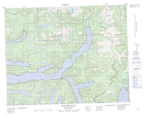
092M02 Seymour Inlet Canada topo map, 1:50,000 scale
092M02 Seymour Inlet NRCAN topographic map.
Includes UTM and GPS geographic coordinates (latitude and longitude). This 50k scale map is suitable for hiking, camping, and exploring, or you could frame it as a wall map.
Printed on-demand using high resolution, on heavy weight and acid free paper, or as an upgrade on a variety of synthetic materials.
Topos available on paper, Waterproof, Poly, or Tyvek. Usually shipping rolled, unless combined with other folded maps in one order.
- Product Number: NRCAN-092M02
- Parent Topo: TOPO-092M
- Map ID also known as: 092M02, 92M2, 92M02
- Unfolded Size: Approximately 26" high by 36" wide
- Weight (paper map): ca. 55 grams
- Map Type: POD NRCAN Topographic Map
- Map Scale: 1:50,000
- Geographical region: British Columbia, Canada
Neighboring Maps:
All neighboring Canadian topo maps are available for sale online at 1:50,000 scale.
Purchase the smaller scale map covering this area: Topo-092M
Spatial coverage:
Topo map sheet 092M02 Seymour Inlet covers the following places:
- Alison Sound - Belize Inlet - Frederick Sound - Haig Bay - Maunsell Bay - Safe Cove - Salmon Arm - Seymour Inlet - Shelter Cove - Wigwam Bay - Bluff Point - Brew Peninsula - Dine Point - Green Point - Howard Point - Martin Point - Miles Point - Nose Point - Taaltz Point - Towry Point - Eclipse Narrows - Wakeman Sound - Poison Bluff - Alalco Indian Reserve 8 - Dug-da-myse Indian Reserve 12 - Graveyard Indian Reserve 9 - Kuthlo Indian Reserve 18 - Kyidagwis Indian Reserve 2 - Owh-wis-too-a-wan Indian Reserve 10 - Pel-looth'l kai Indian Reserve 17 - Peneece Indian Reserve 11 - Réserve indienne Alalco 8 - Réserve indienne Dug-da-myse 12 - Réserve indienne Kuthlo 18 - Réserve indienne Kyidagwis 2 - Réserve indienne Owh-wis-too-a-wan 10 - Réserve indienne Pel-looth'l kai 17 - Réserve indienne Peneece 11 - Réserve indienne Waump 16 - Réserve indienne Wawwat'l 12 - Waump Indian Reserve 16 - Wawwat'l Indian Reserve 12 - Boomerang Lake - Huaskin Lake - Marion Lake - McGregor Lake - Nepah Lagoon - Chaîne Côtière - Coast Mountains - Finger Mountain - Mount Cooper - Mount Verney - Pacific Ranges - Perpendicular Mountain - Rapid Cone - Sir Harry Range - Snowdrift Mountain - Snowdrift Range - Tottenham Range - Village Mountain - Regional District of Mount Waddington - Belize Creek - Canoe Creek - Frederic Creek - Rainbow Creek - Saghalie Creek - Seymour River - Taaltz Creek - Waamtx Creek - Waamtx River - Wakeman River - Waump Creek - Wawwatl Creek


