
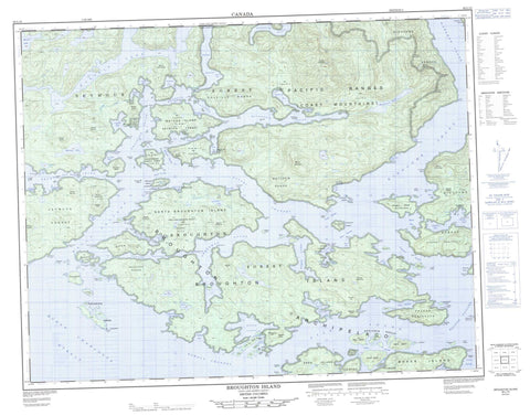
092L15 Broughton Island Canada topo map, 1:50,000 scale
092L15 Broughton Island NRCAN topographic map.
Includes UTM and GPS geographic coordinates (latitude and longitude). This 50k scale map is suitable for hiking, camping, and exploring, or you could frame it as a wall map.
Printed on-demand using high resolution, on heavy weight and acid free paper, or as an upgrade on a variety of synthetic materials.
Topos available on paper, Waterproof, Poly, or Tyvek. Usually shipping rolled, unless combined with other folded maps in one order.
- Product Number: NRCAN-092L15
- Parent Topo: TOPO-092L
- Map ID also known as: 092L15, 92L15
- Unfolded Size: Approximately 26" high by 36" wide
- Weight (paper map): ca. 55 grams
- Map Type: POD NRCAN Topographic Map
- Map Scale: 1:50,000
- Geographical region: British Columbia, Canada
Neighboring Maps:
All neighboring Canadian topo maps are available for sale online at 1:50,000 scale.
Purchase the smaller scale map covering this area: Topo-092L
Spatial coverage:
Topo map sheet 092L15 Broughton Island covers the following places:
- Aimee Bay - Berry Cove - Bughouse Bay - Burly Bay - Carriden Bay - Cartwright Bay - Claydon Bay - Cockatrice Bay - Cullen Harbour - Cypress Harbour - Deep Harbour - Dobbin Bay - Drury Inlet - Duck Inlet - Ellen Cove - Frederick Sound - Freshwater Cove - Harry Bay - Hayle Bay - Helen Bay - Hoy Bay - Joe Cove - Kingcome Inlet - Laura Bay - Little Nimmo Bay - McIntosh Bay - McKenzie Cove - Miller Bay - Moore Bay - Napier Bay - Nimmo Bay - O'Brien Bay - Overflow Basin - Ralph Bay - Reid Bay - Restless Bay - Richmond Bay - Shawl Bay - Sir Edmund Bay - Smith Bay - Steamboat Bay - Stopford Bay - Sullivan Bay - Tancred Bay - Tee Bay - Tracey Harbour - Turnbull Cove - Wehlis Bay - Wolf Cove - Woods Bay - Yuki Bay - Alder Point - Anne Point - Arthur Point - Baronet Point - Bath Point - Blount Point - Bold Point - Bourmaster Point - Boyer Point - Bradley Point - Broughton Point - Burt Point - Cane Point - Card Point - Cardale Head - Carter Point - Cartwright Point - Cawston Point - Claypole Point - Codrington Point - Compton Point - Connolly Point - Cumming Point - Cunning Point - Curtis Point - Donald Head - Duff Point - Ellen Point - Fantome Point - Gawler Point - George Point - Gordon Point - Greenway Point - Griffiths Point - Hannant Point - Harbour Point - Hayes Point - Hayle Point - Hopetown Point - Horsford Point - James Point - Jessie Point - Kenneth Point - Linlithgow Point - Moore Point - Morton Point - Nimmo Point - Notice Point - Olivia Point - Pandora Head - Pearse Peninsula - Pemberton Point - Philip Point - Pollard Point - Popplewell Point - Preston Point - Providence Point - Roffey Point - Sharp Point - Sir Edmund Head - Steep Point - Stirling Point - Sullivan Point - Talbot Point - Upton Point - Vigis Point - Village Point - Walker Point - Watson Point - Wicklow Point - Wishart Peninsula - Wolf Point - Wood Point - Woods Point - Booker Passage - Carter Passage - Cramer Passage - Dunsany Passage - Fife Sound - Grappler Sound - Greenway Sound - Hopetown Passage - Indian Passage - Kenneth Passage - Mackenzie Sound - Nowell Channel - Old Passage - Pasley Passage - Patrick Passage - Penphrase Passage - Queen Charlotte Strait - Raleigh Passage - Sharp Passage - Simoom Sound - Stuart Narrows - Sutlej Channel - Wakeman Sound - Wells Passage - Deep Sea Bluff - Thomas Bluff - Hopetown Indian Reserve 10A - Kadis Indian Reserve 11 - Kawages Indian Reserve 4 - Keogh Indian Reserve 3 - Kukwapa Indian Reserve 5 - Kunstamis Indian Reserve 2 - Kunstamis Indian Reserve 2A - Lawanth Indian Reserve 5 - Magwekstala Indian Reserve 10 - Quay Indian Reserve 4 - Réserve indienne Hopetown 10A - Réserve indienne Kadis 11 - Réserve indienne Kawages 4 - Réserve indienne Keogh 3 - Réserve indienne Kukwapa 5 - Réserve indienne Kunstamis 2 - Réserve indienne Kunstamis 2A - Réserve indienne Lawanth 5 - Réserve indienne Magwekstala 10 - Réserve indienne Quay 4 - Atkinson Island - Baker Island - Benjamin Group - Bermingham Island - Blair Islet - Broughton Archipelago - Broughton Island - Buckingham Island - Cecil Island - Davidson Islet - Davies Island - Denham Island - Dickson Island - Drew Island - Drew Islet - Duff Island - Duff Islet - Eden Island - Fly Island - Gregory Island - Insect Island - John Island - Jumper Island - Keating Islet - Kinnaird Island - Lambert Island - Leche Islet - Ligar Island - Ligar Islet - Long Island - Magin Islands - Magin Islets - Maude Island - Maude Islet - Mauve Island - Mauve Islet - Morris Islet - Nelly Islet - Nicholls Island - Nickless Island - Nickless Islet - Nimmo Islet - North Broughton Island - Olden Island - Ommaney Islet - Percy Island - Polkinghorne Islands - Ragged Island - Rees Island - Screen Island - Simpson Island - Stackhouse Island - Surgeon Islands - Surgeon Islets - Thief Island - Tree Island - Tree Islet - Trivett Island - Turner Island - Vincent Island - Watson Island - Allardyce Lake - Booker Lagoon - Broughton Lagoon - Broughton Lake - Buckingham Lake - Bughouse Lake - Eden Lake - Embley Lagoon - Huaskin Lake - Mackenzie Lake - Marion Lake - Martin Lake - May Lake - Nepah Lagoon - Phyllis Lake - Rosemary Lake - Twin Lagoon - Simoom Sound - Burnaby Range - Bushby Hills - Calliope Range - Catherine Hill - Catherine Mountain - Chaîne Côtière - Cliff Mountain - Coast Mountains - Colville Range - Despard Cone - Double Hill - Elizabeth Cone - Lane Hill - Martin Peak - Matthew Range - Melbourne Hill - Mount Ashe - Mount Beckford - Mount Browne - Mount Burrell - Mount Calvert - Mount Connolly - Mount Eliza - Mount Emily - Mount Fermanagh - Mount Florence - Mount Hawes - Mount Hulme - Mount Ick - Mount Jolliffe - Mount Lardner - Mount Morton - Mount Nightingale - Mount Oke - Mount Otway - Mount Parthenope - Mount Pasmore - Mount Plumridge - Mount Simmonds - Mount Stanley - Mount Stephens - Mount Stopford - Mount Thornton Bate - Ottway Hill - Pacific Ranges - Robert Hills - Sir Harry Range - Stoney Mountain - Walkem Cone - Wren Hills - Regional District of Mount Waddington - Roaringhole Rapids - Allardyce Creek - Duck Creek - Embley Creek - Baxter Shoal - Ben Rock - Brig Rock - Fife Rock - Fox Rock - Gore Rock - Gull Rock - Keating Rock - Kinnaird Rock - Notice Rock - Nowell Bank - Pasley Rock - Pym Rock - Pym Rocks - Sharp Shoal - Star Rock - Thief Rocks - Trivett Rock - Voak Rock - Welde Rock - Hopetown - O'Brian Bay - Shawl Bay - Sullivan Bay


