
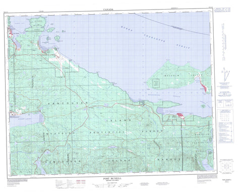
092L11 Port Mcneill Canada topo map, 1:50,000 scale
092L11 Port Mcneill NRCAN topographic map.
Includes UTM and GPS geographic coordinates (latitude and longitude). This 50k scale map is suitable for hiking, camping, and exploring, or you could frame it as a wall map.
Printed on-demand using high resolution, on heavy weight and acid free paper, or as an upgrade on a variety of synthetic materials.
Topos available on paper, Waterproof, Poly, or Tyvek. Usually shipping rolled, unless combined with other folded maps in one order.
- Product Number: NRCAN-092L11
- Parent Topo: TOPO-092L
- Map ID also known as: 092L11, 92L11
- Unfolded Size: Approximately 26" high by 36" wide
- Weight (paper map): ca. 55 grams
- Map Type: POD NRCAN Topographic Map
- Map Scale: 1:50,000
- Geographical region: British Columbia, Canada
Neighboring Maps:
All neighboring Canadian topo maps are available for sale online at 1:50,000 scale.
Purchase the smaller scale map covering this area: Topo-092L
Spatial coverage:
Topo map sheet 092L11 Port Mcneill covers the following places:
- Bear Cove - Beaver Harbour - Hardy Bay - Jensen Cove - Patrician Cove - Port McNeil - Port McNeill - Rough Bay - Rupert Inlet - Bere Point - Broad Point - Daphne Point - Dickenson Point - Dillon Point - False Head - Graeme Point - Lady Ellen Point - Ledge Point - Malcolm Point - Pulteney Point - Single Tree Point - Thomas Point - Broughton Strait - Daedalus Passage - Haddington Passage - Queen Charlotte Strait - Deer Bluff - Port Hardy - Ar-ce-wy-ee Indian Reserve 4 - Fort Rupert Indian Reserve 1 - Keogh Indian Reserve 6 - Kippase Indian Reserve 2 - Klickseewy Indian Reserve 7 - Malcolm Island Indian Reserve 8 - O-tsaw-las Indian Reserve 5 - Réserve indienne Ar-ce-wy-ee 4 - Réserve indienne Fort Rupert 1 - Réserve indienne Keogh 6 - Réserve indienne Kippase 2 - Réserve indienne Klickseewy 7 - Réserve indienne Malcolm Island 8 - Réserve indienne O-tsaw-las 5 - Réserve indienne Shell Island 3 - Réserve indienne Thomas Point 5 - Réserve indienne Thomas Point 5A - Réserve indienne Tsulquate 4 - Réserve indienne Walden 9 - Shell Island Indian Reserve 3 - Thomas Point Indian Reserve 5 - Thomas Point Indian Reserve 5A - Tsulquate Indian Reserve 4 - Walden 9 - Walden Indian Reserve 9 - Wazulis 14 - Cattle Islands - Charlie Islands - Deer Island - Eagle Island - Haddington Island - Malcolm Island - Masterman Islands - Narrow Island - Peel Island - Red Island - Round Island - Shell Island - Alice Lake - Beard Lake - Beaver Lake - Cunningham Lake - D Lake - Frances Lake - Long Lake - Misty Lake - Nimpkish Lake - O'Connor Lake - Sara Lake - Cluxewe Mountain - Downey Hills - The Seven Hills - Twin Peaks - Vancouver Island Mountains - Vancouver Island Ranges - Washlawlis Hill - Regional District of Mount Waddington - Beaver Harbour Park - Lower Nimpkish Park - Beard Creek - Boyden Creek - Cluxewe River - Coetkwaus Creek - Cunningham Creek - Dick Booth Creek - Glenlion River - Hyde Creek - Keekuyzed Creek - Keogh River - Marble River - Mills Creek - Moffat Creek - Nimpkish River - Quatse River - Rupert Creek - Suquash Creek - Tsulquate River - Wah-wese Creek - Washlawlis Creek - Waukwaas Creek - Cormorant Rock - Eel Reef - Haddington Reefs - Herald Rock - Kelp Patch - Keogh Shoals - Neill Ledge - Neill Rock - Numas Bank - Twin Rocks - Port McNeill - Fort Rupert - Hyde Creek - Nimpkish Heights - Sointula - Suquash


