
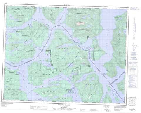
092K06 Sonora Island Canada topo map, 1:50,000 scale
092K06 Sonora Island NRCAN topographic map.
Includes UTM and GPS geographic coordinates (latitude and longitude). This 50k scale map is suitable for hiking, camping, and exploring, or you could frame it as a wall map.
Printed on-demand using high resolution, on heavy weight and acid free paper, or as an upgrade on a variety of synthetic materials.
Topos available on paper, Waterproof, Poly, or Tyvek. Usually shipping rolled, unless combined with other folded maps in one order.
- Product Number: NRCAN-092K06
- Parent Topo: TOPO-092K
- Map ID also known as: 092K06, 92K6, 92K06
- Unfolded Size: Approximately 26" high by 36" wide
- Weight (paper map): ca. 55 grams
- Map Type: POD NRCAN Topographic Map
- Map Scale: 1:50,000
- Geographical region: British Columbia, Canada
Neighboring Maps:
All neighboring Canadian topo maps are available for sale online at 1:50,000 scale.
Purchase the smaller scale map covering this area: Topo-092K
Spatial coverage:
Topo map sheet 092K06 Sonora Island covers the following places:
- Ashlar Cove - Asman Bay - Barnes Bay - Bells Bay - Bickley Bay - Big Bay - Binnington Bay - Bodega Anchorage - Bute Inlet - Cameleon Harbour - Charles Bay - Chonat Bay - Crawford Anchorage - Diamond Bay - Eastwest Bay - Elk Bay - Fanny Bay - Florence Cove - Frances Bay - Frederick Arm - Handfield Bay - Hemming Bay - Horn Bay - Kanish Bay - Mermaid Bay - Nutcracker Bay - Otter Cove - Owen Bay - Phillips Arm - Piddell Bay - Pulton Bay - Ramsay Arm - Rock Bay - Shoal Bay - Small Inlet - Tallac Bay - Thurston Bay - Turn Bay - Vancouver Bay - Waiatt Bay - Woods Bay - Arran Point - Asman Point - Bassett Point - Bernard Point - Brougham Point - Bruce Point - Chatham Point - Chonat Point - Cooper Point - Davis Point - Edward Point - Elk Point - Etta Point - Godwin Point - Granite Point - Greetham Point - Hall Point - Harbott Point - Henrietta Point - Hesler Point - Horn Point - Islet Point - Jackson Point - Johns Point - Kellsey Point - Lawrence Point - Mayes Point - Moriarty Point - Owen Point - Parrott Point - Picton Point - Pulton Point - Raza Point - Richard Point - Shell Point - Slab Point - Sonora Point - Springer Point - Suffolk Point - Thurlow Point - Turnback Point - Venture Point - Walters Point - Whirlpool Point - Wilson Point - Barber Passage - Burgess Passage - Calm Channel - Channe Passage - Discovery Passage - Drew Passage - Gillard Passage - Hole in the Wall - Innes Passage - Johnstone Strait - Mayne Passage - Nodales Channel - Okisollo Channel - Raza Passage - Tugboat Passage - Whiterock Passage - Young Passage - Burnt Bluff - Fawn Bluff - Johnstone Bluff - Pembroke Range - Aupe Indian Reserve 6 - Aupe Indian Reserve 6A - Bartlett Island Indian Reserve 7 - Mushkin Indian Reserve 5 - Mushkin Indian Reserve 5A - Réserve indienne Aupe 6 - Réserve indienne Aupe 6A - Réserve indienne Bartlett Island 7 - Réserve indienne Mushkin 5 - Réserve indienne Mushkin 5A - Réserve indienne Saaiyouck 6 - Saaiyouck Indian Reserve 6 - Bartlett Island - Bartlett Islet - Block Island - Brent Island - Chain Islands - Chained Islands - Channe Island - Chasina Island - Cinque Islands - Cordero Islands - Denham Islet - Dent Island - East Thurlow Island - Eclipse Island - Eclipse Islet - Edsall Islands - Edsall Islets - Erasmus Island - Francisco Island - Gillard Island - Gillard Islands - Gomer Island - Grant Island - Hardinge Island - Haro Island - Howe Island - Jimmy Judd Island - Lee Islands - Limestone Island - Little Dent Island - Lorte Island - Maurelle Island - Metcalf Islands - Mink Island - Nixon Island - Noel Islet - Octopus Islands - Okis Islands - Pinhorn Islet - Quadra Island - Raza Island - Read Island - Rendezvous Islands - Rocky Islets - Rowland Island - Sonora Island - Stuart Island - Thurlow Islands - Tully Island - Turn Island - Vancouver Island - West Thurlow Island - Artificial Lake - Ashlar Lake - Caesar Lake - Caroline Lake - Chonat Lake - Dorr Lake - Edith Lake - Egerton Lake - Elephant Lake - Florence Lake - Heidrick Lake - Hemming Lake - Hyacinth Lake - Jap Lake - Leask Lake - Max Lake - May Lake - Mellin Lake - Mitchell Lake - Newton Lake - Ricardo Lake - Simmons Lake - St. Aubyn Lake - Stella Lake - Stokes Lake - Storey Lake - Vera Lake - Chaîne Côtière - Coast Mountains - Discovery Mountain - Downie Range - Elephant Mountain - Estero Peak - Mount Brougham - Mount Eldon - Mount Muehle - Mount Stokes - Mount Tucker - Mount Turnbull - Pacific Ranges - San Josef Mountain - Toba Mountain - Treble Mountain - Regional District of Comox-Strathcona - Octopus Islands Marine Park - Octopus Islands Recreation Area - Rendezvous Island South Park - Rock Bay Marine Park - Small Inlet Marine Park - Small Inlet Park - Thurston Bay Marine Park - Arran Rapids - Devils Hole - Lower Rapids - Upper Rapids - Yuculta Rapids - Ashlar Creek - Don Creek - Egerton Creek - Grassy Creek - Leask Creek - St. Aubyn Creek - Dent Rapids - Barnsley Shoal - Beaver Rock - Bentley Rock - Bjerre Rock - Crook Rock - Cyrus Rocks - Denham Rock - Douglas Rock - Engels Rock - Entry Ledge - Gypsy Shoal - Jimmy Judd Reef - Maycock Rock - Menace Rock - Min Rock - Nixon Rock - Peel Rocks - Sea Lion Rock - Secord Rock - Siwash Rock - Snag Rock - Big Bay - Church House - Elk Bay - Owen Bay - Rock Bay - Shoal Bay - Stuart Island - Thurlow - Thurston Bay - Yuculta Landing


