
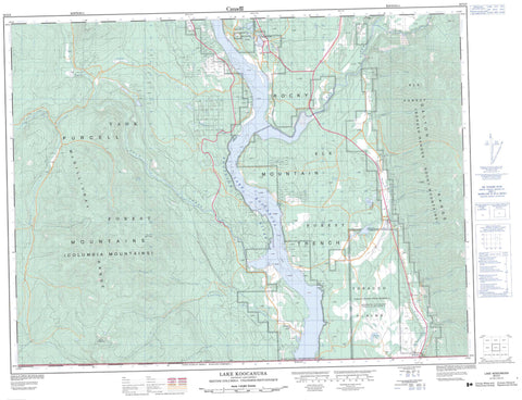
082G03 Lake Koocanusa Canada topo map, 1:50,000 scale
082G03 Lake Koocanusa NRCAN topographic map.
Includes UTM and GPS geographic coordinates (latitude and longitude). This 50k scale map is suitable for hiking, camping, and exploring, or you could frame it as a wall map.
Printed on-demand using high resolution, on heavy weight and acid free paper, or as an upgrade on a variety of synthetic materials.
Topos available on paper, Waterproof, Poly, or Tyvek. Usually shipping rolled, unless combined with other folded maps in one order.
- Product Number: NRCAN-082G03
- Parent Topo: TOPO-082G
- Map ID also known as: 082G03, 82G3, 82G03
- Unfolded Size: Approximately 26" high by 36" wide
- Weight (paper map): ca. 55 grams
- Map Type: POD NRCAN Topographic Map
- Map Scale: 1:50,000
- Geographical region: British Columbia, Canada
Neighboring Maps:
All neighboring Canadian topo maps are available for sale online at 1:50,000 scale.
Purchase the smaller scale map covering this area: Topo-082G
Spatial coverage:
Topo map sheet 082G03 Lake Koocanusa covers the following places:
- Réserve indienne Tobacco Plains 2 - Tobacco Plains Indian Reserve 2 - Lynn Island - Baynes Lake - Chain Lake - Edwards Lakes - Fussee Lake - Lake Koocanusa - Loon Lake - Shotnana Lake - Surveyors Lake - Twin Lake - Border Ranges - Columbia Mountains - Galton Range - Gold Mountain - McGillivray Range - Montagnes Rocheuses - Mount Fitzpatrick - Plumbob Mountain - Purcell Mountains - Rocky Mountains - Sheep Mountain - Regional District of East Kootenay - Kikomun Creek Park - Tobacco Plains - Bloom Creek - Bowman Creek - Caven Creek - Conner Creek - Donald Creek - Elk River - Englishman Creek - Flag Creek - Gold Creek - Kootenay River - Linklater Creek - Maguire Creek - Miller Creek - Phillipps Creek - Purcell Creek - Rainbow Creek - Raymond Creek - Red Canyon Creek - Reserve Creek - Scherf Creek - Sink Creek - Wigwam River - Willie Phillipps Creek - Baynes Lake - Dorr - Flagstone - Flagstone (Grasmere Loc.) - Grasmere - Krag - Kragmont - Newgate - Roosville - Waldo - Grasmere Valley - Rocky Mountain Trench


