
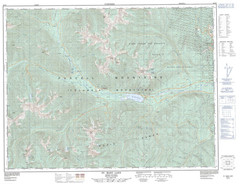
082F09 St Mary Lake Canada topo map, 1:50,000 scale
082F09 St Mary Lake NRCAN topographic map.
Includes UTM and GPS geographic coordinates (latitude and longitude). This 50k scale map is suitable for hiking, camping, and exploring, or you could frame it as a wall map.
Printed on-demand using high resolution, on heavy weight and acid free paper, or as an upgrade on a variety of synthetic materials.
Topos available on paper, Waterproof, Poly, or Tyvek. Usually shipping rolled, unless combined with other folded maps in one order.
- Product Number: NRCAN-082F09
- Parent Topo: TOPO-082F
- Map ID also known as: 082F09, 82F9, 82F09
- Unfolded Size: Approximately 26" high by 36" wide
- Weight (paper map): ca. 55 grams
- Map Type: POD NRCAN Topographic Map
- Map Scale: 1:50,000
- Geographical region: British Columbia, Canada
Neighboring Maps:
All neighboring Canadian topo maps are available for sale online at 1:50,000 scale.
Purchase the smaller scale map covering this area: Topo-082F
Spatial coverage:
Topo map sheet 082F09 St Mary Lake covers the following places:
- Kimberley - Ailsa Lake - Dipper Lake - Hall Lake - Mayo Lake - St. Mary Lake - White Boar Lake - Bootleg Mountain - Columbia Mountains - Evans Mountain - Higgins Peak - Mount Bonner - Mount Evans - Mount McKay - Mount Murphy - Moyie Range - North Star Hill - Purcell Mountains - Pyramid Mountain - Sullivan Hill - White Grouse Mountain - Regional District of East Kootenay - Alki Creek - Angus Creek - Argyle Creek - Bannock Creek - Bothe Creek - Denver Creek - Dewar Creek - Dublin Creek - Fiddler Creek - Flatrock Creek - France Creek - Glasgow Creek - Goat River - Hall Lake Creek - Hellroaring Creek - Hungry Creek - Lisbon Creek - London Creek - Mallandaine Creek - Mark Creek - Matthew Creek - Meachen Creek - Morris Creek - Murphy Creek - Paisley Creek - Paris Creek - Parkers Creek - Perry Creek - Pitt Creek - Pudding Burn - Pyramid Creek - Redding Creek - Resort Creek - Rome Creek - Sawdust Creek - Sawmill Creek - St. Mary River - Tower Creek - White Creek - Meachams - Meachen - North Star - Mallandaine Pass - Murphy Pass


