
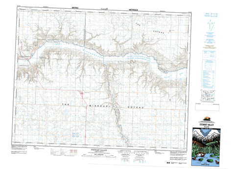
072J12 Stewart Valley Canada topo map, 1:50,000 scale
072J12 Stewart Valley NRCAN topographic map.
Includes UTM and GPS geographic coordinates (latitude and longitude). This 50k scale map is suitable for hiking, camping, and exploring, or you could frame it as a wall map.
Printed on-demand using high resolution, on heavy weight and acid free paper, or as an upgrade on a variety of synthetic materials.
Topos available on paper, Waterproof, Poly, or Tyvek. Usually shipping rolled, unless combined with other folded maps in one order.
- Product Number: NRCAN-072J12
- Parent Topo: TOPO-072J
- Map ID also known as: 072J12, 72J12
- Unfolded Size: Approximately 26" high by 36" wide
- Weight (paper map): ca. 55 grams
- Map Type: POD NRCAN Topographic Map
- Map Scale: 1:50,000
- Geographical region: Saskatchewan, Canada
Neighboring Maps:
All neighboring Canadian topo maps are available for sale online at 1:50,000 scale.
Purchase the smaller scale map covering this area: Topo-072J
Spatial coverage:
Topo map sheet 072J12 Stewart Valley covers the following places:
- Landing Bay - Omache Bay - Russel Bay - Russell Bay - Swift Current Bay - Rebman Point - Coteau (The) - The Coteau - The Missouri Coteau - Lake Diefenbaker - Gray Lookout - Nollet Lookout - Excelsior No. 166 - Lacadena No. 228 - Saskatchewan Landing No. 167 - Victory No. 226 - Matador Grasslands Protected Area - Saskatchewan Landing Provincial Park - Gracie Creek - Juniper Creek - Landing Creek - Matador Creek - Perrin Creek - Rivière Saskatchewan Sud - Russel Creek - Russell Creek - Smith Creek - South Saskatchewan River - Swift Current Creek - Swiftcurrent Creek - Valentine Creek - Yates Creek - Bearpaw Bend - Gunderson - Saskatchewan Landing - Brunyee Coulee - Beaver Flat - Stewart Valley


