
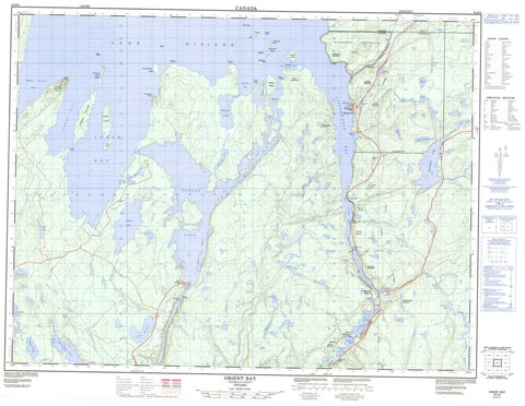
052H08 Orient Bay Canada topo map, 1:50,000 scale
052H08 Orient Bay NRCAN topographic map.
Includes UTM and GPS geographic coordinates (latitude and longitude). This 50k scale map is suitable for hiking, camping, and exploring, or you could frame it as a wall map.
Printed on-demand using high resolution, on heavy weight and acid free paper, or as an upgrade on a variety of synthetic materials.
Topos available on paper, Waterproof, Poly, or Tyvek. Usually shipping rolled, unless combined with other folded maps in one order.
- Product Number: NRCAN-052H08
- Parent Topo: TOPO-052H
- Map ID also known as: 052H08, 52H8, 52H08
- Unfolded Size: Approximately 26" high by 36" wide
- Weight (paper map): ca. 55 grams
- Map Type: POD NRCAN Topographic Map
- Map Scale: 1:50,000
- Geographical region: Ontario, Canada
Neighboring Maps:
All neighboring Canadian topo maps are available for sale online at 1:50,000 scale.
Purchase the smaller scale map covering this area: Topo-052H
Spatial coverage:
Topo map sheet 052H08 Orient Bay covers the following places:
- Albert Bay - Orient Bay - Pijitawabik Bay - Pipestone Bay - South Bay - Three Mount Bay - Bowerman Point - Chisel Point - Chisel Rock - Columbus Point - Cooke Point - Frenchmans Head - Long Point - Otter Head - Pipestone Point - Queen Anne Point - Three Mount Point - The Devils Elbow - Pijitawabik Palisades - Cascade Falls - Gorge Creek Falls - Little Cascade Falls - Virgin Falls - White Chute - Kilkenny - Kitto - Thunder Bay - Réserve indienne Rocky Bay 1 - Rocky Bay 1 - Rocky Bay Indian Reserve 1 - Albert Island - Big Virgin Island - Channel Island - Fitzpatrick Island - Flag Island - Gypsy Island - Head Island - Jardine Island - Lighthouse Island - Little Virgin Island - Louise Island - McKee Island - Naonan Island - Pipestone Island - Prince Alfred Island - Prince of Wales Island - The Virgins - Treasure Island - Victoria Island - Aerial Lake - Awning Lake - Beartrap Lake - Bernice Lake - Bonner Lake - Brouse Lake - Bullrush Lake - Corner Lake - Cox Lake - Coyne Lake - Dive Lake - Double Loon Lake - Downey Lake - Dump Lake - Elizabeth Lake - Emma Lake - Fen Lake - Forgan Lake - Francis Lake - Frill Lake - Froggy Lake - Gelapa Lake - Gorge Lake - Gull Rock Lake - Hannah Lake - Hausen Lake - Hetton Lake - Hynrick Lake - Jeem Lake - Keemle Lake - Lac Nipigon - Lake Nipigon - Leonard Lake - Little Bonner Lake - Little PostagoniLake - Lucky Lake - McAvay Lake - McAvay Lake - McKirdy Lake - North Oskawe Lake - North Sinclair Lake - Obie Lake - Odic Lake - Omer Lake - Ore Lake - Osier Lake - Oskawe Lake - Pack Lake - Padre Lake - Pain Lake - Palace Lake - Pawky Lake - Pennon Lake - Pester Lake - Pew Lake - Piper Lake - Postagoni Lake - Pot Lake - Reflection Lake - Screen Lake - Shadow Lake - Shamrock Lake - Shirley Lake - Sinclair Lake - Slipper Lake - Snell Lake - Stride Lake - Susie Lake - Udell Lake - Wanogu Lake - Green Mountain - Kefkatikgwam Mountain - Kitchi Mountain - Lookout Mountain - Macdiarmid Hill - Mount Mackie - Mount McKirdy - Mount Muntar - Mount Norma - Natawnga Mountain - Reflection Mountain - Scott Mountain - Wasowko Mountain - Beardmore - Nakina - Lake Nipigon Provincial Park - Nipigon Palisades Conservation Reserve - Devil Rapids - Little Devil Rapids - Miners Rapids - Rabbitt Rapids - Bonner Creek - Cash Creek - Cox Creek - Gelapa Creek - Gorge Creek - Hausen Creek - Jackfish River - Keemle Creek - Little Postagoni River - Nipigon River - Obie Creek - Ore Creek - Oskawe Creek - Phantom Creek - Postagoni River - Rivière Nipigon - Shadow Creek - Flatrock Portage - Island Portage - Little Flatrock Portage - Long Portage - Pine Portage - Split Rock Portage - Seagull Reef - Greenstone - Cove Inlet - East McKirdy - Fairloch - Farlinger - Macdiarmid - McKirdy - Orient Bay - Pine Portage


