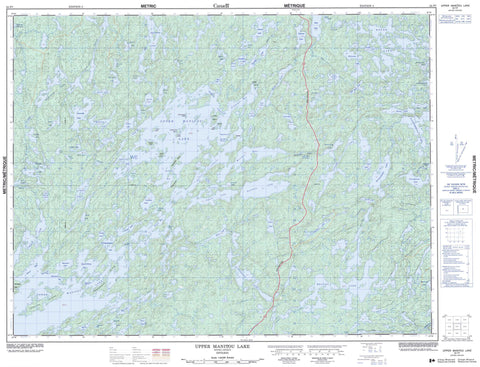
052F07 Upper Manitou Lake Canada topo map, 1:50,000 scale
052F07 Upper Manitou Lake NRCAN topographic map.
Includes UTM and GPS geographic coordinates (latitude and longitude). This 50k scale map is suitable for hiking, camping, and exploring, or you could frame it as a wall map.
Printed on-demand using high resolution, on heavy weight and acid free paper, or as an upgrade on a variety of synthetic materials.
Topos available on paper, Waterproof, Poly, or Tyvek. Usually shipping rolled, unless combined with other folded maps in one order.
- Product Number: NRCAN-052F07
- Parent Topo: TOPO-052F
- Map ID also known as: 052F07, 52F7, 52F07
- Unfolded Size: Approximately 26" high by 36" wide
- Weight (paper map): ca. 55 grams
- Map Type: POD NRCAN Topographic Map
- Map Scale: 1:50,000
- Geographical region: Ontario, Canada
Neighboring Maps:
All neighboring Canadian topo maps are available for sale online at 1:50,000 scale.
Purchase the smaller scale map covering this area: Topo-052F
Spatial coverage:
Topo map sheet 052F07 Upper Manitou Lake covers the following places:
- Benson Bay - Blanchard Bay - Bolton Bay - Doyle Bay - Garnet Bay - Glass Bay - Honeymoon Bay - Jackfish Bay - Mosher Bay - Niven Bay - Olsen Bay - O'Shaughnessy Bay - Reliance Bay - Rush Bay - Shaughnessy Bay - Three-O-Three Bay - Trafalgar Bay - Sandpiper Point - Beaverhead Narrows - Birch Narrows - Blind Narrows - Four Mile Narrows - Manitou Straits - Red Rock Narrows - Walker's Narrows - Watson's Narrows - Watson's Falls - Beaverhead Island - Charley Rock Island - Frenchman Island - Gold Island - Gold Island - Gravel Gertie Island - Green Island - Leuiller Island - Manitou Island - McGraw Island - Rochon Island - Stony Island - Swede Boys Island - Trout Island - Arm Lake - Beck Lake - Bell Lake - Benson Lake - Big Manitumeig Lake - Blanchard Lake - Bolton Lake - Boyer Lake - Butterfly Lake - Cane Lake - Carleton Lake - Crooked Lake - Dog Lake - Donnelly Lake - Dorothy Lake - Double Lake - Doyle Lake - Doyle Lake - Early Lake - Ethel Lake - Etta Lake - Gabbro Lake - Goose Egg Lake - Green Lake - Harper Lake - Helen Lake - Holcroft Lake - Johnar Lake - Jonas (Bell) Lake - Jonas Lake - Kabagukski Lake - Kamanatogama Lake - Kaminni Lake - Kekekwa Lake - Kennewapekko Lake - Kenny Lake - Kinnyu Lake - Kirkby Lake - Knowles Lake - Landon Lake - Levit Lake - Little Merrill Lake - Lower Manitou Lake - Lower Walmsley Lake - Manitumeig Lake - Marius Lake - Marshall Lake - Medwick Lake - Meggisi Lake - Merrill Lake - Mitchell Lake - Moose Lake - Mountain Lake - Mountdew Lake - Mud Lake - Navimar Lake - Noonan Lake - Noswal Lake - Peak Lake - Peekaboo Lake - Pincher Lake - Ponto Lake - Pothole Lake - Power Lake - Rajar Lake - Rattlesnake Lake - Rawlinson Lake - Rector Lake - Rubanoe Lake - Sasakwei Lake - Scattergood Lake - Secret Lake - Seggemak Lake - Selby Lake - Sharp Lake - Shongwashu Lake - Skinny Lake - Starshine Lake - Summit Lake - Sunshine Lake - Surprise Lake - Taylor Lake - Thundercloud Lake - Troutlet Lake - Troutlet Lake - Twin Narrows Lake - Uphill Lake - Upper Manitou Lake - Wakek Lake - Walmsley Lake - Washeibemaga Lake - Wawapus Lake - Wolf Howl Lake - Kaopskikamak River - Kawashegamuk River - Long Lake River - Pincher Creek - Rabbit Brook - Rattlesnake Creek - Rawlinson Creek - Scattergood Creek - Trout River - Walmsley Creek - Wawapus Creek - Swede Portage - Gold Rock


