
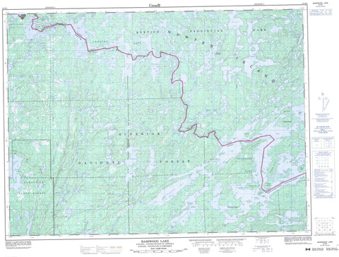
052B04 Basswood Lake Canada topo map, 1:50,000 scale
052B04 Basswood Lake NRCAN topographic map.
Includes UTM and GPS geographic coordinates (latitude and longitude). This 50k scale map is suitable for hiking, camping, and exploring, or you could frame it as a wall map.
Printed on-demand using high resolution, on heavy weight and acid free paper, or as an upgrade on a variety of synthetic materials.
Topos available on paper, Waterproof, Poly, or Tyvek. Usually shipping rolled, unless combined with other folded maps in one order.
- Product Number: NRCAN-052B04
- Parent Topo: TOPO-052B
- Map ID also known as: 052B04, 52B4, 52B04
- Unfolded Size: Approximately 26" high by 36" wide
- Weight (paper map): ca. 55 grams
- Map Type: POD NRCAN Topographic Map
- Map Scale: 1:50,000
- Geographical region: Ontario, Canada
Neighboring Maps:
All neighboring Canadian topo maps are available for sale online at 1:50,000 scale.
Purchase the smaller scale map covering this area: Topo-052B
Spatial coverage:
Topo map sheet 052B04 Basswood Lake covers the following places:
- Bayley Bay - Big Merriam Bay - Gardner Bay - Little Merriam Bay - Lost Bay - Merriam Bay - Merriam Bay - Moose Bay - North Bay - Ranger Bay - Canadian Point - King Point - Norway Point - English Channel - Basswood Falls - Curtain Falls - Lower Basswood Falls - Rebecca Falls - Wheelbarrow Falls - Rainy River - Cabin 16 Island - Christmas Island - Cigar Island - Elk Lake - Four Island - Hunter Island - Irving Island - Neil Island - Ottawa Island - Ranger Island - Rookery Island - Salchert Island - Solandt Island - White Island - Argo Lake - Bart Lake - Basswood Lake - Cecil Lake - Craig Lake - Crooked Lake - Greer Lake - Iron Lake - Isabella Lake - Kahshahpiwi Lake - Kett Lake - Lac la Croix - Little Newt Lake - Little Roland Lake - Lost Lake - Low Lake - McAree Lake - McIntyre Lake - McNaught Lake - Middle Roland Lake - Milt Lake - Nest Lake - Newt Lake - Nub Lake - Point Lake - Robinson Lake - Round Lake - Sarah Lake - Side Lake - Ted Lake - Tuck Lake - Valley Lake - Wilson Lake - Gardners Mountain - Quetico Provincial Park - Bottle Rapids - Basswood River - Bottle River - Kett Creek - McIntyre Creek - Namakan River - Siobhan River - Tuck River - Wheelbarrow Portage - Lac la Croix


