
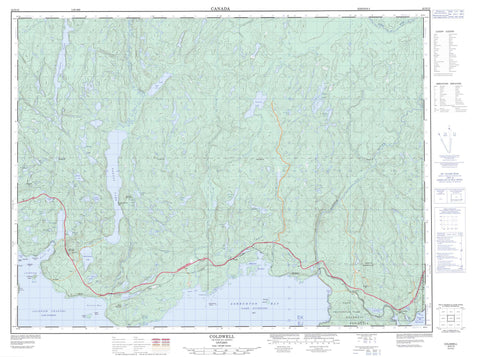
042D15 Coldwell Canada topo map, 1:50,000 scale
042D15 Coldwell NRCAN topographic map.
Includes UTM and GPS geographic coordinates (latitude and longitude). This 50k scale map is suitable for hiking, camping, and exploring, or you could frame it as a wall map.
Printed on-demand using high resolution, on heavy weight and acid free paper, or as an upgrade on a variety of synthetic materials.
Topos available on paper, Waterproof, Poly, or Tyvek. Usually shipping rolled, unless combined with other folded maps in one order.
- Product Number: NRCAN-042D15
- Parent Topo: TOPO-042D
- Map ID also known as: 042D15, 42D15
- Unfolded Size: Approximately 26" high by 36" wide
- Weight (paper map): ca. 55 grams
- Map Type: POD NRCAN Topographic Map
- Map Scale: 1:50,000
- Geographical region: Ontario, Canada
Neighboring Maps:
All neighboring Canadian topo maps are available for sale online at 1:50,000 scale.
Purchase the smaller scale map covering this area: Topo-042D
Spatial coverage:
Topo map sheet 042D15 Coldwell covers the following places:
- Ashburton Bay - Bottle Cove - Cork Cove - Jackfish Bay - Jims Harbour - McKellar Harbour - Mink Harbour - Moberley Bay - Peninsula Bay - Port Coldwell - Prairie Cove - Prisoner Cove - Ripple Bay - Santoy Bay - Tunnel Bay - Cape Victoria - Coldwell Peninsula - Observation Point - Prince Point - Windigo Wigwam Point - Jackfish Channel - 78 - 79 - 80 - 81 - 82 - Coldwell - Grain - Syine - Tuuri - Walsh - Barclay Islands - Cody Island - Lawson Island - St. Patrick Island - Angel Lake - Bass Lake - Beaverdam Lake - Black Fox Lake - Bonne Lake - Box Lake - Cairngorm Lake - Canoe Lake - Cedar Lake - Christie Lake - Dam Lake - Dead Horse Lake - Deb Lake - Del Lake - Diablo Lake - Echo Lake - Echo Lake - Eric Lake - Fishnet Lake - Foxtrap Lake - Foxxe Lake - Glory Lake - Goldbar Lake - Gordon Lake - Grassy Lake - Islealone Lake - Jackfish Lake - Johnny Lake - Lac Supérieur - Lake Superior - Larry Lake - Little Davidson Lake - Little Santoy Lake - Little Steel Lake - Lunch Lake - McCraig Lake - McKellar Lake - McLaren Lake - Moon Lake - Neys Lake - Noslo Lake - Pack Lake - Pony Lake - Poulin Lake - Prospect Lake - Prospect South Lake - Ripple Lake - Robertson Lake - Sandy Lake - Santoy Lake - Sawmill Lake - Spider Lake - Tunnel Lake - Empress Hill - Granite Mountain - Mount Premier - Premier Mountain - Santoy Mountain - Steel Mountain - Terrace Bay - Fishnet Lake Conservation Reserve - Neys Provincial Park - Prairie River Mouth Provincial Nature Reserve - Steel River Provincial Park - Culvert Creek - Dead Horse Creek - Diablo Creek - Fishnet Creek - Foxtrap Creek - Glory Creek - Larry Creek - Little Pic River - Martinet Creek - McKellar Creek - Mink Creek - Mink River - Neys Creek - Owl Creek - Prairie River - Ripple Creek - Santoy Creek - Sawmill Creek - Steel River - Worthington Creek - Bare Rock - Fitzsimmons Rocks - Haiste Rocks - Jack Rock - Little Nick Rock - Marathon - Coldwell - Jack Fish - Jackfish - Middleton - Neys - Port Coldwell - Ripple - Santoy - Steel


