
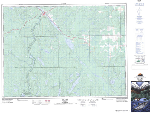
041P09 Elk Lake Canada topo map, 1:50,000 scale
041P09 Elk Lake NRCAN topographic map.
Includes UTM and GPS geographic coordinates (latitude and longitude). This 50k scale map is suitable for hiking, camping, and exploring, or you could frame it as a wall map.
Printed on-demand using high resolution, on heavy weight and acid free paper, or as an upgrade on a variety of synthetic materials.
Topos available on paper, Waterproof, Poly, or Tyvek. Usually shipping rolled, unless combined with other folded maps in one order.
- Product Number: NRCAN-041P09
- Parent Topo: TOPO-041P
- Map ID also known as: 041P09, 41P9, 41P09
- Unfolded Size: Approximately 26" high by 36" wide
- Weight (paper map): ca. 55 grams
- Map Type: POD NRCAN Topographic Map
- Map Scale: 1:50,000
- Geographical region: Ontario, Canada
Neighboring Maps:
All neighboring Canadian topo maps are available for sale online at 1:50,000 scale.
Purchase the smaller scale map covering this area: Topo-041P
Spatial coverage:
Topo map sheet 041P09 Elk Lake covers the following places:
- Mountain Chutes - Auld - Banks - Barber - Beauchamp - Bryce - Cane - Henwood - James - Lundy - Mickle - Roadhouse - Speight - Timiskaming - Tudhope - Wallis - Willet - Alexander Lake - Alma Lake - Auld Lake - Banks Lake - Barber Lake - Big Spring Lake - Boland Lake - Boucher Lake - Burgess Lake - Callicut Lake - Canyon Lake - Collacutt Lake - Cooke Lake - Crane Lake - Dacy Lake - Deserted Lake - Devlin Lake - Downey Lake - East Kidd Lake - Echo Lake - Elk Lake - Etwill Lake - Frederick Lake - Gillies Lake - Grace Lake - Gut Lake - Harebell Lake - Heather Lake - Henderson Lake - Hill Lake - Hill's Lake - Honeymoon Lake - Hope Lake - Indian Lake - Jamtama Lake - Kingston Lake - Lamble Lake - Leacock Lake - Lepha Lake - Little Skull Lake - Little Spring Lake - Makobe Lake - McKenzie Lake - Mendelssohn Lake - Mountain Lake - Munroe Lake - Philbrick Lake - Red Lily Lake - Reed Lake - Rose Lake - Schumann Lake - Scugog Lake - Shane Lake - Silverclaim Lake - Skull Lake - Sunday Lake - Swampgrass Lake - Tallpipe Lake - Thin Lake - Thomson Lake - Tud Lake - Wallis Lake - Younger Lake - James - Big Spring Lake Bedrock Conservation Reserve - Bryce and Cane Township Wetland Lacustrine Conservation Reserve - Indian Bay South Conservation Reserve - Lady Evelyn-Smoothwater Provincial Park - Makobe Grays Ice Margin Conservation Reserve - Makobe-Grays River Provincial Park - Mountain Chutes Rapids - Barber Creek - Bear River - Burgess Creek - Crane Creek - Cucumber Creek - Dacy Creek - Etwill Creek - Evanturel Creek - Hilda Creek - Honeymoon Creek - Jamtama Creek - Lamble Creek - Leacock Creek - Lepha Creek - Makobe River - Mickle Creek - Montreal River - Moosehorn Creek - Silverclaim Creek - Spray Creek - Spring Creek - St. Jean Baptiste Creek - Sunday Creek - Tamarac Creek - Wabun Creek - Willow Island Creek - Cane - Elk Lake - Hill Lake - Hill's Lake - Leeville - Mountain Chutes - Mountain Lake - Osseo - Osseo - Wilson


