
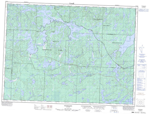
041O13 Nicholson Canada topo map, 1:50,000 scale
041O13 Nicholson NRCAN topographic map.
Includes UTM and GPS geographic coordinates (latitude and longitude). This 50k scale map is suitable for hiking, camping, and exploring, or you could frame it as a wall map.
Printed on-demand using high resolution, on heavy weight and acid free paper, or as an upgrade on a variety of synthetic materials.
Topos available on paper, Waterproof, Poly, or Tyvek. Usually shipping rolled, unless combined with other folded maps in one order.
- Product Number: NRCAN-041O13
- Parent Topo: TOPO-041O
- Map ID also known as: 041O13, 41O13
- Unfolded Size: Approximately 26" high by 36" wide
- Weight (paper map): ca. 55 grams
- Map Type: POD NRCAN Topographic Map
- Map Scale: 1:50,000
- Geographical region: Ontario, Canada
Neighboring Maps:
All neighboring Canadian topo maps are available for sale online at 1:50,000 scale.
Purchase the smaller scale map covering this area: Topo-041O
Spatial coverage:
Topo map sheet 041O13 Nicholson covers the following places:
- Bird Bath Bay - Bland Bay - Fagus Bay - Grazing Inlet - Healey Bay - Nicholson Bay - Phone Line Bay - Wayland Bay - Dividing Narrows - 13G - 23,23 - 24,21 - 24,22 - 32 - 35 - 36 - 37 - Bliss - Caouette - Caverley - Cosens - D'Avaugour - Druillettes - Gilliland - Hill - Hoey - Panet - Peters - Recollet - Shawkence - Strathearn - Topham - Triquet - Adagio Lake - Alba Lake - Amelia Lake - Amos Lake - Andrews Lake - Arva Lake - Austin Lake - Babin Lake - Bacon Lake - Baker Lake - Balfour Lake - Banana Lake - Bevin Lake - Big Pine Lake - Bowstring Lake - Brusaw Lake - Canthook Lake - Ceepee Lake - Chagnon Lake - Chambers Lake - Coe Lake - Colin Lake - Como Lake - Coot Lake - Cosens Lake - Dean Lake - Dixon Lake - Dorman Lake - Dunne Lake - Eyelet Lake - Fergus Lake - Fife Lake - Flicker Lake - Flint Lake - Glabb Lake - Goodwin Lake - Grazing Lake - Greb Lake - Hansen Lake - Hap Lake - Henna Lake - Highbrush Lake - Hoey Lake - Horseshoe Lake - Huff Lake - Hurd Lake - Jaybee Lake - Kathleen Lake - Kennedy Lake - Knife Lake - Knob Lake - Lac Como - Lawson Lake - Leonard Lake - Little Island Lake - Little Pine Lake - Little Spencer Lake - Little Wawa Lake - Loon Cry Lake - Lower Prairie Bee Lake - Mackey Lake - Mal Lake - McNiece Lake - Milton Lake - Morden Lake - Morris Lake - Musk Lake - Nagasin Lake - Nicholson Lake - Oxygen Lake - Papoose Lake - Pardee Lake - Peavey Lake - Peters Lake - Picard Lake - Pigs Eye Lake - Pillow Lake - Ponoka Lake - Prairie Bee Lake - Prim Lake - Ralph Lake - Rousseau Lake - Sauriol Lake - Scully Lake - Sideburned Lake - Sissons Lake - Slim Lake - Sloth Lake - Soretooth Lake - Spencer Lake - Splint Lake - Square Lake - String Lake - Sunset Lake - Therien Lake - Topham Lake - Tribe Lake - Triplet Lake - Triquet Lake - Wangoon Lake - Watson Lake - Wilkison Lake - Windermere Lake - Zag Lake - The Shoals Provincial Park - Windermere Goldie Lake Complex Conservation Reserve - Brusaw Creek - Chaplin River - Colin Creek - Como Creek - Grazing River - Hayes Creek - Hoey Creek - Kebsquasheshing River - Kennedy Creek - Little Missinaibi River - Little Wawa Creek - Nebskwashi River - Prairie Bee River - Rivière Windermere - Sissons Creek - Wilkison Creek - Windermere River - Esher - Musk - Nicholson - Pardee


