
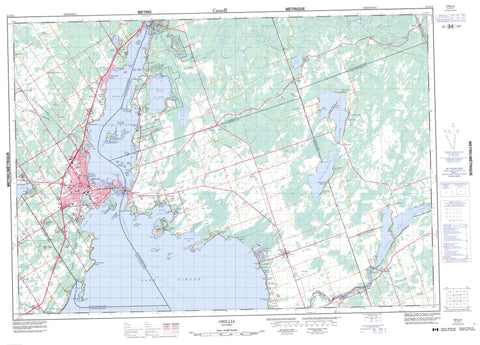
031D11 Orillia Canada topo map, 1:50,000 scale
031D11 Orillia NRCAN topographic map.
Includes UTM and GPS geographic coordinates (latitude and longitude). This 50k scale map is suitable for hiking, camping, and exploring, or you could frame it as a wall map.
Printed on-demand using high resolution, on heavy weight and acid free paper, or as an upgrade on a variety of synthetic materials.
Topos available on paper, Waterproof, Poly, or Tyvek. Usually shipping rolled, unless combined with other folded maps in one order.
- Product Number: NRCAN-031D11
- Parent Topo: TOPO-031D
- Map ID also known as: 031D11, 31D11
- Unfolded Size: Approximately 26" high by 36" wide
- Weight (paper map): ca. 55 grams
- Map Type: POD NRCAN Topographic Map
- Map Scale: 1:50,000
- Geographical region: Ontario, Canada
Neighboring Maps:
All neighboring Canadian topo maps are available for sale online at 1:50,000 scale.
Purchase the smaller scale map covering this area: Topo-031D
Spatial coverage:
Topo map sheet 031D11 Orillia covers the following places:
- Barnstable Bay - Brewery Bay - Carthew Bay - Cunningham Bay - Grays Bay - Hopkins Bay - Invermara Bay - McPhee Bay - Old Brewery Bay - Pumpkin Bay - Quarry Bay - Shannon Bay - Shingle Bay - Shingle Bay - Smith's Bay - St. Ives Bay - Woods Bay - Moose Beach - Avery Point - Barnfield Point - Black Point - Brechin Point - Cedar Point - Champlain Point - Concord Point - Couchiching Point - Eight Mile Point - Floral Point - Four Mile Point - Gamebridge Point - Heward Point - Invermara Point - Leacock Point - McGinnis Point - McRae Point - Mooley Point - Muley Point - Mulley Point - Orchard Point - Owaissa Point - Plumb Point - Prophet Point - Victoria Point - The Narrows - Kawartha Lakes - Orillia - Carden - Dalton - Digby - Eldon - Laxton - Mara - Ontario - Orillia - Oro - Rama - Mnjikaning First Nation 32 - Rama First Nation Indian Reserve 32 - Rama Indian Reserve 32 - Réserve indienne Mnjikaning First Nation 32 - Réserve indienne Rama 32 - Réserve indienne Rama First Nation 32 - Bird Island - Cedar Island - Chiefs Island - Dry Shoal Islet - Garnet Island - Goat Island - Goffatt Island - Grape Island - Green Island - Heron Island - Herring Island - Horseshoe Island - Île Beausoleil - Little Falls Island - Nadie Island - Orillia Island - Portage Island - Rama Island - Ship Island - Strawberry Island - Thistle Island - Bass Lake - Buck Lake - Canal Lake - Couchiching Lake - Cranberry Lake - Dalrymple Lake - Kelly Lake - Lake Couchiching - Lake Simcoe - Lake St. George - Lake St. John - Mud Lake - Young Lake - Logan Hill - Durham - Ontario - Simcoe - United Counties of Northumberland and Durham - Victoria - Bexley - Bobcaygeon/Verulam - Brock - Carden - Carden/Dalton - Dalton - Eldon - Emily - Fenelon - Laxton, Digby and Longford - Manvers - Mara - Mariposa - Medonte - Ops - Orillia - Oro-Medonte - Rama - Ramara - Severn - Somerville - South Orillia - Verulam - Bass Lake Provincial Park - Canal Lake Concrete Arch Bridge National Historic Site of Canada - Dalton Digby Wildlands Provincial Park - Lieu historique national du Canada de la Voie-Navigable-Trent--Severn - Lieu historique national du Canada du Pont-de-Béton-en-Arc-du-Lac-Canal - Lieu historique national du Canadades Barrages-de-Pêche-Mnjikaning - Mara Provincial Park - McRae Point Provincial Park - Mnjikaning Fish Weirs National Historic Site of Canada - Trent--Severn Waterway National Historic Site of Canada - Black River - Bluffs Creek - Butternut Creek - Cranberry River - Deverells Creek - Grouse Creek - Hawkestone Creek - Head River - North River - Severn River - Silver Creek - St. John Creek - Sucker Creek - Talbot River - Wainman's Creek - Eight Mile Shoal - Maynards Shoal - Moons Shoal - The Limestones - Trout Shoal - Whiskey Shoal - Whitefish Shoal - Amigo Beach - Ardtrea - Atherley - Avery Point - Bass Lake Park - Bayshore Village - Baywood Park - Bolsover - Bonnie Beach - Brechin - Brechin Beach - Brechin East - Brechin Point - Buena Vista Park - Campbells Beach - Carlyon - Carthew - Carthew Bay - Cedarmont Beach - Concord Point - Cumberland Beach - Dalrymple - East Oro - Eight Mile Point - Eldon - Eldon Station - Fawkham - Fawn Bay - Fergus Hill Estate - Floral Park - Forest Home - Fountain Beach - Gamebridge - Gamebridge Beach - Geneva Park - Glenrest Beach - Grays Bay - Greys Bay - Hampshire Mills - Happyland - Harry's Corner - Hawkestone - Hawkins Corners - Joyland Beach - Lagoon City - Lake Dalrymple - Lakeview Beach - Longford - Longford Mills - MacDonald Beach - Maple Avenue - Maple Valley - Mara Beach - Mariposa Beach - McCrackins Beach - Menoke Beach - Millington - Moons Beach - Murphy Beach - New Gamebridge Beach - New Uhthoff - North Mara - Oaklawn Beach - O'Connell - Orchard Point - Orkney Beach - Point of Mara Beach - Portage Road - Prophet Beach - Prophet Point - Rama - Rama Road - Rathburn - Rohallion - Rugby - Sandy Beach - Sandy Point Beach - Scarlet Park - Schepeler - Sebright - Simcoe Lodge - South View - South View - Southview Beach - Southview Cove - Sylvan Glen Beach - Tafton - Talbot - Tanglewood Beach - Udney - Uhthoff - Uphill - Uptergrove - Victoria Point - Washago - Wilson Point


