
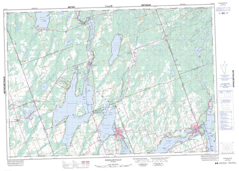
031D10 Fenelon Falls Canada topo map, 1:50,000 scale
031D10 Fenelon Falls NRCAN topographic map.
Includes UTM and GPS geographic coordinates (latitude and longitude). This 50k scale map is suitable for hiking, camping, and exploring, or you could frame it as a wall map.
Printed on-demand using high resolution, on heavy weight and acid free paper, or as an upgrade on a variety of synthetic materials.
Topos available on paper, Waterproof, Poly, or Tyvek. Usually shipping rolled, unless combined with other folded maps in one order.
- Product Number: NRCAN-031D10
- Parent Topo: TOPO-031D
- Map ID also known as: 031D10, 31D10
- Unfolded Size: Approximately 26" high by 36" wide
- Weight (paper map): ca. 55 grams
- Map Type: POD NRCAN Topographic Map
- Map Scale: 1:50,000
- Geographical region: Ontario, Canada
Neighboring Maps:
All neighboring Canadian topo maps are available for sale online at 1:50,000 scale.
Purchase the smaller scale map covering this area: Topo-031D
Spatial coverage:
Topo map sheet 031D10 Fenelon Falls covers the following places:
- Cranberry Bay - Crane Bay - Ellery Bay - Fells Bay - Green Bay - Hawkers Bay - Long Point Bay - McFarland Bay - Nogies Creek Bay - Nories Bay - North Bay - Sackett Bay - South Bay - Stumpy Bay - West Bay - Potts Shore - Ancona Point - Birch Point - Birch Point - Birch Point - Black Point - Chimney Point - Cottage Point - Daniels Point - Deihl Point - Falls Point - Gregory Point - Hughes Point - Indian Point - Isaacs Point - Laidlaw Point - Lighthouse Point - Lightning Point - Long Point - Mackenzie Point - North River Point - Olivers Point - Potts Point - Rocky Point - South River Point - Stinsons Point - Big Bob Channel - Little Bob Channel - Kawartha Lakes - Elliott Falls - Fenelon Falls - Bexley - Carden - Digby - Eldon - Fenelon - Galway - Harvey - Laxton - Somerville - Verulam - Victoria - Islands in the Trent Waters Indian Reserve 36A - Réserve indienne Islands in the Trent Waters 36A - Ant Island - Armstrong Island - Ball Island - Beacon Island - Big Island - Birch Island - Bottom Islands - Boyd Island - Boyd Island - Cherry Island - Dead Horse Island - Delamere Island - Delemere Island - Deweys Island - Grand Island - Greeny Island - Hogg Island - Isle of View - McConnell Island - Muskrat Island - Pennington's Island - Rathbun Island - Steamboat Island - Togo Island - Balsam Lake - Bass Lake - Beech Lake - Beechnut Lake - Brush Lake - Cameron Lake - Crystal Lake - Duck Lake - Four MileLake - Goose Lake - Head Lake - Johnston Lake - Kawartha Lakes - Kirkfield Lake - Little Silver Lake - Mitchell Lake - Oak Lake - Perch Lake - Pigeon Lake - Raven Lake - Rush Lake - Shadow Lake - Silver Lake - Soap Lake - Sturgeon Lake - Talbot Lake - Venner Lake - Galena Hill - Moore Hill - United Counties of Northumberland and Durham - Victoria - Bexley - Bobcaygeon/Verulam - Carden - Carden/Dalton - Dalton - Eldon - Emily - Fenelon - Galway and Cavendish - Galway-Cavendish and Harvey - Harvey - Laxton, Digby and Longford - Manvers - Mariposa - Ops - Somerville - Verulam - Balsam Lake Provincial Park - Indian Point Provincial Park - Lieu historique national du Canada de la Voie-Navigable-Trent--Severn - Trent--Severn Waterway National Historic Site of Canada - Bobcaygeon River - Burnt River - Corben Creek - Fenelon River - Grass Creek - Gull River - Hawkers Creek - Head River - Lavery Creek - Loom Creek - Martin Creek - Martin Creek - Nogies Creek - Pearns Creek - Perch Creek - Perrin Creek - Rosedale River - Rutherford Creek - Staples River - Union Creek - Venner Creek - Dead Horse Shoal - Grand Rock - Hogg Rock - Long Point Shoal - Three Sisters Shoals - Togo Rock - Ancona Point - Baddow - Bexley - Birch Point - Bobcaygeon - Burnt River - Burys Green - Camp Kagawong - Coboconk - Corsons - Dongola - Fell - Fenelon Falls - Galena Hill - Head Lake - Isaacs Glen - Kenstone Beach - Kirkfield - Long Point - Norland - Raven Lake - Red Rock - Rosedale - Silver Lake - Union Creek - Verulam Park - Victoria Road - Watsons


