
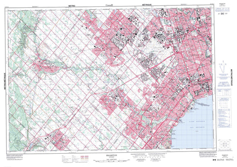
030M12 Brampton Canada topo map, 1:50,000 scale
030M12 Brampton NRCAN topographic map.
Includes UTM and GPS geographic coordinates (latitude and longitude). This 50k scale map is suitable for hiking, camping, and exploring, or you could frame it as a wall map.
Printed on-demand using high resolution, on heavy weight and acid free paper, or as an upgrade on a variety of synthetic materials.
Topos available on paper, Waterproof, Poly, or Tyvek. Usually shipping rolled, unless combined with other folded maps in one order.
- Product Number: NRCAN-030M12
- Parent Topo: TOPO-030M
- Map ID also known as: 030M12, 30M12
- Unfolded Size: Approximately 26" high by 36" wide
- Weight (paper map): ca. 55 grams
- Map Type: POD NRCAN Topographic Map
- Map Scale: 1:50,000
- Geographical region: Ontario, Canada
Neighboring Maps:
All neighboring Canadian topo maps are available for sale online at 1:50,000 scale.
Purchase the smaller scale map covering this area: Topo-030M
Spatial coverage:
Topo map sheet 030M12 Brampton covers the following places:
- Brampton - Mississauga - Toronto - Milton Heights - Niagara Escarpment - Hilton Falls - Caledon - Chinguacousy - East York - Erin - Esquesing - Etobicoke - Halton - Nassagaweya - Nelson - North York - Peel - Toronto - Toronto Gore - Trafalgar - Wellington - York - York - Claireville Reservoir - Heart Lake - Kelso Lake - Lac Ontario - Lake Aquitaine - Lake Ontario - Lake Wabukayne - Mill Pond - Scotch Block Reservoir - Halton - Metropolitan Toronto - Peel - Wellington - Chinguacousy - Chinguacousy - Erin - Esquesing - Esquesing - Nassagaweya - Toronto - Toronto Gore - West Garafraxa - Kelso Conservation Area - Applewood Creek - Berry Creek - Birchwood Creek - Black Creek - Black Creek - Carolyn Creek - Cawthra Creek - Cook Creek - Cooksville Creek - Credit River - Credit River (Georgetown Branch) - Credit River (Georgetown Branch) - Credit River West Branch - East Sixteen Mile Creek - Elmcrest Creek - Emery Creek - Etobicoke Creek - Fletchers Creek - Glen Erin Brook - Humber Creek - Humber River - Joshua's Creek - Kenollie Creek - Levi's Creek - Little Etobicoke Creek - Lornewood Creek - Loyalist Creek - Mary Fix Creek - Masseygrove Creek - Middle Oakville Creek - Middle Sixteen Mile Creek - Mimico Creek - Mullet Creek - Mullett Creek - Renforth Creek - Rivière Credit - Rivière Humber - Rogers Creek - Rowntree Creek - Sawmill Creek - Serson Creek - Sheridan Creek - Silver Creek - Silver Creek - Silver Creek - Sixteen Mile Creek - Snows Creek - Spring Creek - Stavebank Creek - Tecumseh Creek - Turtle Creek - Wabukayne Creek - West Humber River - Wolfedale Creek - Albion - Caledon - Central Halton - Erin - Halton Hills - Milton - North Halton - Oakville - Agerton - Alderwood - Alloa - Applewood Acres - Applewood Heights - Applewood Hills - Armbro Heights - Ashgrove - Baby Point - Beaumonde Heights - Beverley Hills - Birchwood - Bloordale Gardens - Boston - Bramalea - Bramalea Woods - Britannia - Browns Line - Burnhamthorpe - Cheltenham - Cherry Hill - Chestnut Hills - Christie - Churchville - Claireville - Clarkson - Clearview - Cooksville - Delrex - Derry West - Dixie - Dixie Station - Dorset Park - Drumquin - Eldorado Park - Elmbank - Erin Mills - Erindale - Erindale Station - Erindale Woodlands - Eringate - Etobicoke - Etobicoke - Fairhaven - Fairview - Fairview Heights - Frasers Corners - Georgetown - Glen Agar - Glen Leven - Glen Williams - Golden Acres - Gorewood Acres - Grahamsville - Hanlan - Hardington - Highfield - Hollywood - Hornby - Hornby Station - Humber Valley - Humberlea - Huttonsville - Huttonville - Islington - Kelso - Kingsview Village - Kipling Heights - Lakeview - Lambton Mills - Limehouse - Lisgar - Lisgar Station - Long Branch - Lorne Park - Lorne Park Estates - Madoc - Malton - Mansewood - Markland Woods - Martin Grove Gardens - Marvin Heights - Marywood Meadows - Meadow Wood - Meadowvale - Meadowvale South - Meadowvale Station - Meadowvale Village - Meadowvale West - Milton Heights - Milton West - Mimico - Mississauga Valley - Moore Park - Mount Charles - Mount Olivet - Mount Pleasant - New Toronto - North York - Northwood Park - Nortonville - Norval - Norval Station - Obico Station - Omagh - Orchard Heights - Park Royal - Peel Village - Peru - Pine Point - Pleasant - PortCredit - Princess Anne Manor - Princess Margaret - Queensway Station - Rattray Park Estates - Rexdale - Richview - Richview Gardens - Ridgehill - Ridgewood - Riverview - Scotch Block - Shep - Sheridan - Sheridan Homelands - Sheridan Park - Sherwood Forrest - Silver Creek - Silverthorne West - Six Points - Snelgrove - Snider - Speyside - Springbrook - St. Phillips - Stewartown - Stewartown Station - Stewarttown - Stewarttown Station - Streetsville - Streetsville Junction - Summerville - Summerville Station - Terra Cotta - The Kingsway - Thistletown - Thorncrest Village - Vista - Vista Heights - West Deane Park - West Humber Estates - Westmount - Weston - Whaley Corners - Whaley's Corners - Wildwood - Woodhill - York - Hungry Hollow - Eglinton Flats - Rattray Marsh


