
022I08 Mingan Canada topo map, 1:50,000 scale
022I08 Mingan NRCAN topographic map.
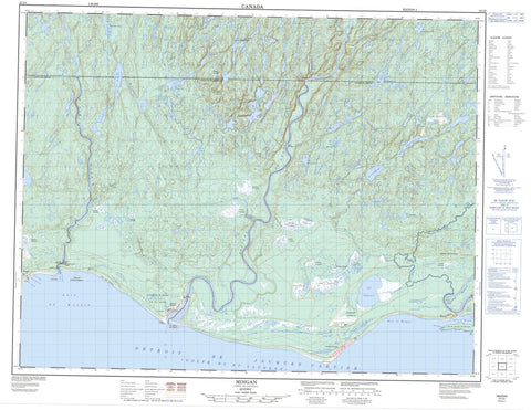
Includes UTM and GPS geographic coordinates (latitude and longitude). This 50k scale map is suitable for hiking, camping, and exploring, or you could frame it as a wall map.
Printed on-demand using high resolution, on heavy weight and acid free paper, or as an upgrade on a variety of synthetic materials.
Topos available on paper, Waterproof, Poly, or Tyvek. Usually shipping rolled, unless combined with other folded maps in one order.
- Product Number: NRCAN-022I08
- Parent Topo: TOPO-022I
- Map ID also known as: 022I08, 22I8, 22I08
- Unfolded Size: Approximately 26" high by 36" wide
- Weight (paper map): ca. 55 grams
- Map Type: POD NRCAN Topographic Map
- Map Scale: 1:50,000
- Geographical region: Quebec, Canada
Neighboring Maps:
All neighboring Canadian topo maps are available for sale online at 1:50,000 scale.
Purchase the smaller scale map covering this area: Topo-022I
Spatial coverage:
Topo map sheet 022I08 Mingan covers the following places:
- Aéroport de Mingan - Anse à Bonhomme - Anse à Charles - Anse à Élaire - Anse à Wellie - Anse des Girard - Anse du Vieux Quai - Baie à Béliveau - Baie de Magpie - Baie de Mingan - Baie Kapihtuakaupet - Baie Kauahat - Havre de Magpie - Havre de Mingan - Grève des Phoques - La Longue Pointe - Pointe à Robin - Pointe Akam Nekau - Pointe Ekuantshiu Ministuk Ouest - Pointe Kauapehekat - Pointe Matsitew - Détroit de Jacques-Cartier - Passe Kakahtsheuenant - Passe Uepapiskat - Coteau Kapikuahenenant - Chute Kastjekawt - Chute Opmeso - Chutes Kakahtshekaut - Chutes Nakatshuan Mantu Hipis - Fornel - Mingan - Rocamadour - Saint-François-d'Assise - Saint-Jean - Barrage Magpie - Mingan - Mingan Indian Reserve - Réserve indienne Mingan - Cayes de la Rivière Magpie - Île à Jos - Île du Havre de Mingan - Île Harbour - Île Kamikuapiskat - Île Wapinew - Îles à Ross - Îles Ministukueuetshuan - Petite île Mantus - Rocher Ministukuapisk - Rocher Wacouta - Kaomaskwianipi - Kawashaonipi - Kawipushkatnipi - Lac à Baptiste - Lac à Boucher - Lac à Castor - Lac à Fleur - Lac à Louis-Boucher - Lac à Narcisse - Lac à Pierre - Lac à Willie - Lac à Zabette - Lac Atikuspawakut - Lac aux Éboulis - Lac Beleney - Lac Castor - Lac Chaudron - Lac de la Fonderie - Lac de la Tour - Lac des Deux Chutes - Lac des Girard - Lac des Montagnes - Lac des Rats Musqués - Lac Édouard - Lac Hatché - Lac Kahiuakamist - Lac Kaianakapeshakamat - Lac Kaianipakamat - Lac Kakuanaihetshitihk - Lac Kakwanesetsitish - Lac Kamastshekwa - Lac Kamatshimatakap - Lac Kamitshekiwista - Lac Kamuhuakamat - Lac Kanotshukutowew - Lac Kaonokotoshonant - Lac Kapmitihekakamat - Lac Kasawatsitish - Lac Katakutawatsitish - Lac Katnokomat - Lac Kauipuhkat - Lac Kauipuskat - Lac Kwanejsetsitisis - Lac Long - Lac Maskwian - Lac Matshimatakap - Lac Misekamat Okwastipekw - Lac Mitshekiwista - Lac Opwatan - Lac Patterson - Lac Rond - Lac Simillon - Lac Takutawatsitish - Lac Wapanatsio - Lac Washao - Lac Waskwej - Lac Wipushkat - Lacs de la Grande Plaine - Lacs Kapinekupat - Petit lac Salé - Mont Saint-Jean - Mingan Archipelago National Park Reserve of Canada - Réserve de parc national du Canada de l'Archipel-de-Mingan - Rapides Kapemistauatshetshuan - Bras du Ouest - Le Grand Ruisseau - North West Manitou River - Opmeso Sipis - Rivière Béline - Rivière Chambers - Rivière Chambers Est - Rivière Kaopmosiosipis - Rivière Magpie - Rivière Manitou - Rivière Manitou - Rivière Manitou Nord-Ouest - Rivière Mingan - Rivière Saint-Coeur - Rivière Saint-Jean - Ruisseau à la Truite - Ruisseau à Méo - Ruisseau à Wellie - Ruisseau Béline - Ruisseau Blanc - Ruisseau Kapinekupat - Ruisseau Nutapanatsheuan - Ruisseau Opwatan Sipis - Ruisseau Patterson - Ruisseau Utitshipeu Amisk - Confluent Takuahkuiat Mantu Hipis - Confluent Takuahkuiat Umitshiu Hipis - Confluent Takuahkuiat Upuat'n Hipis - Piste Kahkam Petshunan - Pont à Léon - Pont André-Roussy - Portage Kakastsheuatakant - Portage Kaskamestakan - Portage Notsiskotowew - Portage Pastapistnakan - Portage Umitshiu - Le Bout du Banc - Source Kakuahkuetshuaht - Kakuian Ekutnt - Kamikuapiskat - Kaministnahkuteht - Longue-Pointe-de-Mingan - Magpie - Mingan - Rivière-Saint-Jean - Ueht Ka Tshitaikant - Grande plaine de Saint-Jean - Longue-Pointe - Longue-Pointe-de-Mingan - Rivière-Saint-Jean


