
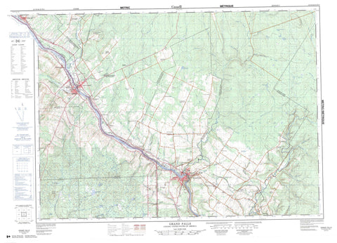
021O04 Grand Falls Canada topo map, 1:50,000 scale
021O04 Grand Falls NRCAN topographic map.
Includes UTM and GPS geographic coordinates (latitude and longitude). This 50k scale map is suitable for hiking, camping, and exploring, or you could frame it as a wall map.
Printed on-demand using high resolution, on heavy weight and acid free paper, or as an upgrade on a variety of synthetic materials.
Topos available on paper, Waterproof, Poly, or Tyvek. Usually shipping rolled, unless combined with other folded maps in one order.
- Product Number: NRCAN-021O04
- Parent Topo: TOPO-021O
- Map ID also known as: 021O04, 21O4, 21O04
- Unfolded Size: Approximately 26" high by 36" wide
- Weight (paper map): ca. 55 grams
- Map Type: POD NRCAN Topographic Map
- Map Scale: 1:50,000
- Geographical region: New Brunswick, Canada
Neighboring Maps:
All neighboring Canadian topo maps are available for sale online at 1:50,000 scale.
Purchase the smaller scale map covering this area: Topo-021O
Spatial coverage:
Topo map sheet 021O04 Grand Falls covers the following places:
- Grand Falls - Petit Sault - Denmark - Drummond - Saint-André - Saint-Léonard - Basley Lake - Lac à Minet - Lac Castonguay - Lac Castonquay - Little Barkerhouse Lake - Ryan Brook Lake - Stony Lake - Drummond Hill - Waddell Hill - Saint-Léonard Provincial Park - Rapide de Femme - White Rapids - Anderson Brook - Baker Brook - Bakerhouse Brook - Barney Brook - Basley Brook - Beaver Brook - Beaver Brook - Beaverdam Brook - Bill Brook - Black Brook - Bogan Brook - Brandy Brook - Caldwell Brook - Chambord Brook - Club Brook - Coombes Brook - Côté Brook - Dead Brook - Deadwater Brook - Depot Brook - Donat Brook - Evans Brook - Falls Brook - Fifteen Mile Tree Brook - Foley Brook - Godin Brook - Graham Brook - Graham Brook - Grand River (Grande Rivière) - Grande Rivière - Harrison Brook - Keating Brook - LaForge Brook - Lake Branch - Leslie Brook - Little Beaver Brook - Little Otter Slide Brook - Little River - Little Salmon River - Lynch Brook - McCluskey Brook - Mill Stream - Mooney Brook - Otter Slide Brook - Page Brook - Perkins Brook - Poitras Brook - Powers Brook - Powers Creek - Rapide de Femme Creek - Rapide de Femme Stream - Rivière Saint-Jean - Rivière Siegas - Rocky Brook - Ruisseau Desjardins - Ryan Brook - Saint John River - Salmon River - Siegas River - Simpson Brook - Sirois Brook - Six Mile Brook - Sutherland Brook - Ten Mile Brook - Wood Brook - Grand Falls - Grand-Sault - Saint-Léonard - St. Leonard - Bellefleur - Bellefleur Station - Burgess Settlement - Caldwell - Canton - Colebrooke West - Comeau Ridge - Coombes Road - Côté - Cyr Junction - Davis - Davis Mill - Desjardins Road - Drummond Station - Drummond Station - Ennishone - Ennishore - Foley Brook - Godbout - Grand Falls Portage - Grand Falls Station - Grand-Ruisseau - Harrison Brook Settlement - Hennigar Corner - L'Eglise - L'Eglise - Levesque Settlement - Martin - Martin Siding - McManus Siding - New Denmark Station - Notre-Dame-de-Lourdes - Parents - Poitras - Poitras Siding - Powers Creek - Price Road - Priceburg - Quatre-Coins - Rang-des-Bourgoin - Saint-Amand - Saint-Léonard-Parent - Siegas - St. Amand - St-Amand - Upper Siegas - Violette Bridge - Violette Settlement - Violette Station - Woodville - Forbes Gulch - Drummond - Sainte-Anne-de-Madawaska - St. André - St. André de Madawaska - St-André-de-Madawaska


