
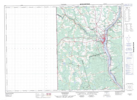
021J04 Woodstock Canada topo map, 1:50,000 scale
021J04 Woodstock NRCAN topographic map.
Includes UTM and GPS geographic coordinates (latitude and longitude). This 50k scale map is suitable for hiking, camping, and exploring, or you could frame it as a wall map.
Printed on-demand using high resolution, on heavy weight and acid free paper, or as an upgrade on a variety of synthetic materials.
Topos available on paper, Waterproof, Poly, or Tyvek. Usually shipping rolled, unless combined with other folded maps in one order.
- Product Number: NRCAN-021J04
- Parent Topo: TOPO-021J
- Map ID also known as: 021J04, 21J4, 21J04
- Unfolded Size: Approximately 26" high by 36" wide
- Weight (paper map): ca. 55 grams
- Map Type: POD NRCAN Topographic Map
- Map Scale: 1:50,000
- Geographical region: New Brunswick, Canada
Neighboring Maps:
All neighboring Canadian topo maps are available for sale online at 1:50,000 scale.
Purchase the smaller scale map covering this area: Topo-021J
Spatial coverage:
Topo map sheet 021J04 Woodstock covers the following places:
- Essepenack Cove - Grafton Cove - Gyles Cove - Old Kirk Cove - Sigahaw Cove - Woodstock Cove - Grand Bar - Phillips Flat - Sharps Flat - Old Kirk Point - Hays Falls - Jackson Falls - Carleton - Richmond - Wakefield - Woodstock - Woodstock 23 - Bulls Island - Fiddlehead Island - Indian Island - Island Park - Meductic Island - Pine Island - Riordan Island - Riordan Islets - Sharps Island - Woodstock Island - Asphaltes Lake - Bennetts Lake - Curries Lake - Greens Lake - Green's Lake - Hays Lake - Henderson Lake - Mactaquac Lake - Morrison Lake - Mud Lake - Payson Lake - Rosamond Lake - Saunderson Lake - Sherwood Lake - Sherwood Lakes - Benton Ridge - Estabrooks Mountain - Hovey Hill - Iron Ore Hill - Iron Ore Hill - Maple Hill - Moody Hill - Moody Hill - Oak Mountain - Parks Hill - Poverty Peak - Sharps Mountain - Spruce Peak - Ancien palais de justice du comté de Carleton - Dr. George F. Clarke House - Hays Falls Provincial Park Reserve - Maison du Dr. George F. Clarke - Old Carleton County Court House - Ackers Brook - Ackers Creek - Bedell Brook - Bedell Brook - Benn Brook - Bull Creek - Bulls Creek - Caldwell Brook - Campbells Brook - Carters Brook - Clarks Brook - Connell Brook - Connells Brook - Crane Brook - Debec Brook - Downey Brook - Fish Creek - Gibson Creek - Gibson Millstream - Gidney Brook - Hagerman Brook - Harper Brook - Hays Brook - Hodgdon Brook - Hopkins Brook - Johnston Brook - Johnstons Brook - Lanes Creek - Lilly Brook - Little Bedell Brook - MacDonald Brook - Marven Brook - Meduxnekeag River - Mill Brook - Mill Stream - North Branch Meduxnekeag River - North Meduxnekeag River - Peabody Brook - Phillips Creek - Pocomoonshine Brook - Rivière Saint-Jean - Saint John River - Shaws Creek - Shea Brook - Smith Brook - Strongs Brook - Two Mile Brook - Upham Brook - Wallace Brook - Whirly Brook - Wright Brook - Pocomoonshine Deadwater - Woodstock Reach - Clowes Shoals - Woodstock - Bedell - Bedell Settlement - Belleville - Benton Ridge - Blowdown - Blowdown Settlement - Briggs Corner - Bulls Creek - Campbell Settlement - Debec - Debec Junction - Dibblee - Elmwood - Elmwood Station - Farmerston - Ferryville - Flemington - Flemmington - Grafton - Grafton Hill - Green Road - Hartford - Hillman - Houlton Road - Indian Village - Irish Settlement - Ivy Corner - Jackson Falls - Jacksontown - Jacksonville - Limestone - Lindsay - Lower Brighton - Lower Northampton - Lower Wakefield - Lower Waterville - Lower Woodstock - Mapledale - McKenna - McKenzie Corner - Newbridge - Newburg - Newburg Junction - Newburg Settlement - Northampton - Northampton - Oak - Oak Mountain - Oakville - Pembroke - Phillips - Plymouth - Riceville - Richmond Corner - Richmond Settlement - Rosedale - Scott Settlement - South Greenfield - South Newbridge - Speerville - Starkey Corners - Starkey's Corner - Tapley Mills - Tapleys Mills - Teeds Mill - Teeds Mills - Union Corner - Upper Northampton - Upper Woodstock - Valley - Wakefield - Watson Settlement - Wickham - Smoky Hollow - The Gully - Meduxnekeag Intervale


