
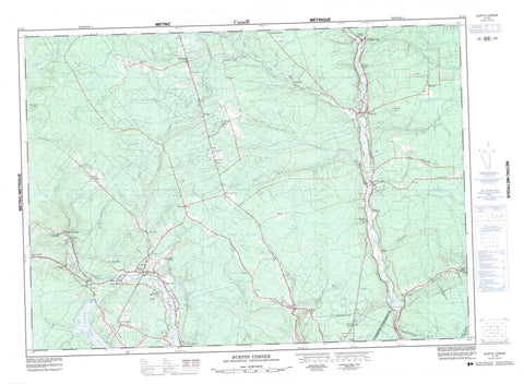
021J02 Burtts Corner Canada topo map, 1:50,000 scale
021J02 Burtts Corner NRCAN topographic map.
Includes UTM and GPS geographic coordinates (latitude and longitude). This 50k scale map is suitable for hiking, camping, and exploring, or you could frame it as a wall map.
Printed on-demand using high resolution, on heavy weight and acid free paper, or as an upgrade on a variety of synthetic materials.
Topos available on paper, Waterproof, Poly, or Tyvek. Usually shipping rolled, unless combined with other folded maps in one order.
- Product Number: NRCAN-021J02
- Parent Topo: TOPO-021J
- Map ID also known as: 021J02, 21J2, 21J02
- Unfolded Size: Approximately 26" high by 36" wide
- Weight (paper map): ca. 55 grams
- Map Type: POD NRCAN Topographic Map
- Map Scale: 1:50,000
- Geographical region: New Brunswick, Canada
Neighboring Maps:
All neighboring Canadian topo maps are available for sale online at 1:50,000 scale.
Purchase the smaller scale map covering this area: Topo-021J
Spatial coverage:
Topo map sheet 021J02 Burtts Corner covers the following places:
- Mactaquac Stream Basin - Fredericton - Dunbar Falls - Douglas - Queensbury - Stanley - Sunbury - York - Penniac Island - Carleton Lake - Dorn Lake - Duck Lake - Fish Lake - Grand John Lake - Killarney Lake - Morehouse Pond - Sams Lake - Stickles Lakes - Thomas Lake - Bluff Hill - Crow Hill - Ducey Hill - Howard Mountain - Howard Peak - Keswick Ridge - Middle Brook Ridge - Mount Hope - Zionville Hill - 42nd Highland Memorial Cemetery - Cimitière 42nd Highland Memorial - Allen Brook - Barker Brook - Baxter Brook - Beaver Brook - Big Brook - Bolster Brook - Bradley Brook - Bully Brook - Campbell Creek - Cleuristic Brook (Dunbar) - Cleuristic Brook (Dunbar) - Corey Brook - Dans Brook - Dobie Brook - Dunbar Brook - Dunbar Brook - Dunbar Stream - East Branch North Forks - East Nashwaaksis Stream - Estey Brook - First Gore Brook - Four Mile Brook - Fraser Brook - Gilmore Brook - Glen Brook - Grand John Brook - Gully Brook - Gully Brook - Gunter Brook - Jakes Brook - Keswick River - Killarney Brook - Lightbody Brook - Limekiln Brook - Little Nashwaaksis Stream - Little Tay Brook - MacLean Settlement Brook - Mactaquac River - Mactaquac Stream - Manzer Brook - McBean Brook - McCallum Brook - McConaghy Brook - McCullough Brook - McKenzie Brook - McKiel Brook - McLean Brook - Meadow Brook - Middle Branch Nashwaaksis Stream - Middle Brook - Middle Brook - Mill Brook - Mill Brook - Mill Brook - Moore Brook - Mularchy Brook - Nashwaak River - Nashwaaksis Stream - Nixon Brook - North Branch Dunbar Stream - North Branch Nashwaaksis Stream - North Branch Penniac Stream - North Cleuristic (Dunbar) Brook - North Dunbar (Cleuristic) Brook - North Dunbar (Cleuristic) Brook - North Nashwaaksis Stream - North Penniac Stream - North Tay River - Penniac Stream - Pidgeon Brook - Pigeon Brook - Porters Brook - Red Brook - Regiment Creek - Robinson Brook - School Brook - Schoolhouse Brook - Second Gore Brook - Seymour Brook - Smokey Brook - South Branch Dunbar Stream - South Branch Mactaquac Stream - South Dunbar (Cleuristic) Brook - South Dunbar Brook - South Tay River - Squirrel Brook - Squirrel Brook - Tay River - Tinkettle Brook - Weary Brook - West Branch Forks Brook - West Branch Nashwaaksis Stream - West Nashwaaksis Stream - Whitlock Brook - Youngs Brook - Jones Forks - Little Forks - North Forks - Birdton - Brewer Mills - Brewers Mill - Brewers Mills - Burtts Corner - Cardigan - Covered Bridge - Dorn Ridge - Durham Bridge - English Settlement - Esteys Bridge - Hamtown Corner - Hurlett - Hurlutt - Jones Forks - Kentville - Keswick - Killarney Road - Kingsley - Lower Durham - Lower Stoneridge - MacLean Settlement - Manzer - McElwain - McLeod Hill - Morehouse Corner - Mount Hope - Mouth of Keswick - Nashwaak - Nashwaak Bridge - Nashwaak Village - North Tay - Penniac - Pleasant Valley - Pughs Crossing - Ross - Royal Road - Royal Road West - Sisson Settlement - Stone Ridge Settlement - Stoneridge - Tay Creek - Tay Falls - Tay Mills - Tay Settlement - Tay Valley - Taymouth - Tripp Settlement - Upper Durham - Upper Keswick - Upper Keswick Ridge - Upper Penniac - Upper Stoneridge - Wellington - Woodland - Woodlands - Zealand - Zealand Station - Zionville - Seymour Meadows - Seymours Meadows


