
021H12 Sussex Canada topo map, 1:50,000 scale
021H12 Sussex NRCAN topographic map.
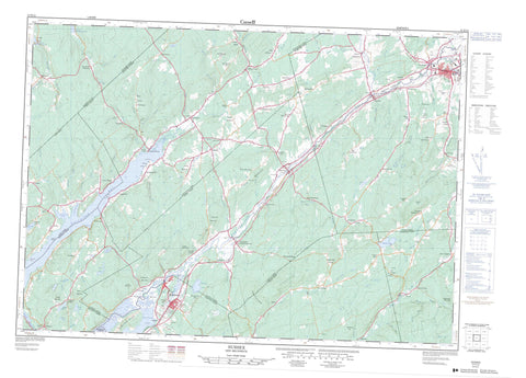
Includes UTM and GPS geographic coordinates (latitude and longitude). This 50k scale map is suitable for hiking, camping, and exploring, or you could frame it as a wall map.
Printed on-demand using high resolution, on heavy weight and acid free paper, or as an upgrade on a variety of synthetic materials.
Topos available on paper, Waterproof, Poly, or Tyvek. Usually shipping rolled, unless combined with other folded maps in one order.
- Product Number: NRCAN-021H12
- Parent Topo: TOPO-021H
- Map ID also known as: 021H12, 21H12
- Unfolded Size: Approximately 26" high by 36" wide
- Weight (paper map): ca. 55 grams
- Map Type: POD NRCAN Topographic Map
- Map Scale: 1:50,000
- Geographical region: New Brunswick, Canada
Neighboring Maps:
All neighboring Canadian topo maps are available for sale online at 1:50,000 scale.
Purchase the smaller scale map covering this area: Topo-021H
Spatial coverage:
Topo map sheet 021H12 Sussex covers the following places:
- Belleisle Bay - Big Cove - Browns Cove - Crafts Cove - Earle Cove - Erbs Cove - Jenkins Cove - Kingston Creek - Rouses Cove - Tennant Cove - Tennants Cove - Urquharts Cove - Webster Beach - Anderson Point - Dutch Point - Grey Point - Greys Point - Kingston Peninsula - Long Point - Hammond - Hampton - Kars - Kings - Kingston - Norton - Queens - Rothesay - Springfield - Studholm - Sussex - Upham - Wickham - Darlings Island - Ghost Island - Butler Lake - Byrnes Lake - Byrns Lake - Cassidy Lake - Cochrane Lake - Darlings Lake - De Forest (Cassidy) Lake - De Forest Lake - Erb Lake - Jack Lake - Kennebecasis Lake - Knapp Lake - Long Lake - McManus Lake - Nice Lake - Pickett Lake - Scribner Lake - Champ de manoeuvre Sussex - Sussex Training Area - Bloomfield Ridge - Boyles Hill - Bull Moose Hill - Cochrane Mountain - Dickie Mountain - Dug Hill - Foster Mountain - Fowler Mountain - Fox Hill - Frost Mountain - Hazel Hill - Hoyts Mountain - Kingston Hill - Marshall Hill - McShane Hill - Passekeag Ridge - Pickwauket Mountain - Pikwaket Mountain - Raymond Mountain - Saddleback Mountain - Vinegar Hill - Hampton Gaol - Prison de Hampton - Elm Flat - Albright Brook - Almshouse Brook - Bates Brook - Bell Brook - Belleisle (Pascobac) Creek - Belleisle (Pascobac) Creek - Belleisle Creek - Bloomfield Brook - Byrnes Brook - Catchem Brook - Clements Brook - Cove Brook - Culligan Brook - Daley Brook - Devil Pike Brook - Dobson Brook - Duncan Brook - Elm Brook - First Run Brook - Fowler Brook - Gold Mine Gully - Grant Brook - Grassy Brook - Grooms Brook - Halfway Brook - Hamilton Brook - Hammond River - Henderson Brook - Henderson Brook - Irish Settlement Brook - Joliff Brook - Joliffs Brook - Jolly Creek - Jones Brook - Kennebecasis River - Ketchum Brook - Lake Brook - Lake Brook - MacDonalds Brook - McCarthy Brook - McDonald Brook - McGonagle Brook - McGregor Brook - McGregor Creek - Mercer Brook - Midland Brook - Mill Brook - Millstream River - Mitchell Brook - Moffatt Brook - Moosehorn Creek - Murphy Brook - Musquash Brook - North Branch Hammond River - North Hammond River - O'Neil Brook - Ossekeag Creek - Pascobac (Belleisle) Creek - Pascobac (Belleisle) Creek - Pascobac Brook - Pascobac Creek - Pascobac Creek - Pascobac Stream - Pascobac Stream - Passekeag Creek - Paticake Creek - Peters Brook - Peters Brook - Pickwauket Brook - Pikwaket Brook - Quigley Brook - Ravine Brook - Reddin Brook - Rouse Brook - Salt Springs Brook - Scoodic Brook - Second Run Brook - Sharpe Brook - Smith Creek - Smiths Creek - Snyder Brook - Spragg Brook - Stewarton Brook - Studholm Brook - Studholm Mill Stream - Studholms Mill Stream - Taylors Brook - Thompson Brook - Titus Brook - Trout Creek - Urquharts Brook - Vails Brook - Ward Creek - Wards Creek - Moffatt Deadwater - The Oxbow - Hampton - Quispamsis - Sussex - Aiton Siding - Apohaqui - Belleisle - Belleisle Creek - Beulah - Bloomfield - Bloomfield Ridge - Bloomfield Station - Bull Moose Hill - Campbell - Campbell Settlement - Case - Case Settlement - Central Norton - Clover Hill - Crafts Cove - Devine Corner - Dickie Mountain - Drury Cove - Drurys Cove - Earle Wharf - Elm Brook - Elmhurst - Erb - Erb Settlement - Erbs Cove - Fox Hill - Gillies Corner - Gillis Corner - Hammondvale - Hampton Station - Hatfield Point - Henderson Settlement - Hillsdale - Joliff Brook - Joliffs Brook - Kars - Keirsteadville - Kingston - Kingston Corner - Lake Side - Lakeside - Long Point - Lower Cove - Lower Kars - Lower Kars - Lower Kingston - Lower Midland - Lower Millstream - Lower Norton - Marchbank - McCain Settlement - Mercer - Mercer Settlement - Midland - Norton Shore - Parleeville - Pascobac - Passekeag - Peekaboo Corner - Pikwaket Mountain - Poodiac - Poodiac - Ratter Corner - Riverbank - Roachville - Saddleback - Salina - Salt Springs - Searsville - Secord - Shannon - Southfield - Southfield Road - Springfield - Stewarton - Tennant Cove - Tennants Cove - The Grant - Tooleton - Upper Belleisle - Upper Midland - Upper Salt Springs - Upper Ward Creek - Upper Wards Creek - Upperton - Vinegar Hill - Wards Creek - West Scotch Settlement - Woodpecker Hall - Yankee Shore - Hampton Marsh - Reickers Intervale - Norton


