
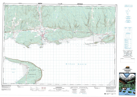
021H08 Parrsboro Canada topo map, 1:50,000 scale
021H08 Parrsboro NRCAN topographic map.
Includes UTM and GPS geographic coordinates (latitude and longitude). This 50k scale map is suitable for hiking, camping, and exploring, or you could frame it as a wall map.
Printed on-demand using high resolution, on heavy weight and acid free paper, or as an upgrade on a variety of synthetic materials.
Topos available on paper, Waterproof, Poly, or Tyvek. Usually shipping rolled, unless combined with other folded maps in one order.
- Product Number: NRCAN-021H08
- Parent Topo: TOPO-021H
- Map ID also known as: 021H08, 21H8, 21H08
- Unfolded Size: Approximately 26" high by 36" wide
- Weight (paper map): ca. 55 grams
- Map Type: POD NRCAN Topographic Map
- Map Scale: 1:50,000
- Geographical region: Nova Scotia, Canada
Neighboring Maps:
All neighboring Canadian topo maps are available for sale online at 1:50,000 scale.
Purchase the smaller scale map covering this area: Topo-021H
Spatial coverage:
Topo map sheet 021H08 Parrsboro covers the following places:
- Amethyst Cove - Big Cove - Clam Cove - Davidson Cove - Dixons Cove - East Bay - Ells Creek - Gentleman Cove - Lady Cove - Little Cove - Little Split Rock Cove - Lobster Hole - Minas Basin - Parrsboro Harbour - Parrsboro Roads - Phinneys Cove - Scots Bay - Scotsman Bay - Scotts Bay - Shad Creek - Sheddley Cove - Turners Cove - West Bay - First Beach - Partridge Island Beach - Sand Point Beach - Second Beach - Blomidon Peninsula - Cape Blomidon - Cape Sharp - Cape Split - Clarke Head - Crane Point - McKay Head - Ram Head - Rams Head - Ramshead Point - Red Head - Sand Point - Sheddley Point - Minas Channel - Bull Bluff - McLaughlin Bluff - Wasson Bluff - Black Rock Woods - Colchester - Cumberland - Hants - Kings - Diamond Island - Egg Island - Five Islands - Long Island - Moose Island - Partridge Island - Pinnacle Island - The Brothers - Black Lake - Cranberry Lake - Duck Lake - Fowler Lake - Gilbert Lake - Gilbert Lake - Hatfields Pond - Jeffers Lake - Leak Lake - Leake Lake - MacAloneys Lake - McAlese Lake - Murray Lake - Otter Lake - Parrsboro Aboiteau - Pleasant Lake - Pleasant Lake - Summit Lake - Wasson Lake - Welton Lake - Blockhouse Hill - Cobequid Mountains - Economy Mountain - Gerrish Mountain - Gilbert Hills - Glasgow Mountain - Kirk Hill - Lynn Mountain - North Mountain - North Mountain Range - Woods Mountain - Colchester - Cumberland - Kings - Blomidon Provincial Park - Chignecto Game Sanctuary - Five Islands Provincial Park - Big Eddy - Adams Brook - Barkhouse Brook - Bass River of Five Islands - Beaver Brook - Big Pike Fire Brook - Black Brook - Borden Brook - Boyd Brook - Broad Brook - Brown Brook - Brown Brook - Bumper Brook - Bumpers Brook - Crane Creek - Dan Jess Brook - Davidson Brook - Dead Horse Brook - Diligent River - Diligent River - Dow Brook - East Branch Diligent River - East Branch Moose River - East Parrsboro River - East River - East River of Five Islands - Eaton Brook - Ells Brook - Ells Brook - Farrell Brook - Farrells River - Five Islands River - Fullerton Brook - Gavin Brook - Glasgow Brook - Gundalow Brook - Hanna Brook - Hannas Brook - Harrington River - Henry Brook - Herbert Tupper Brook - Horse Brook - Humming Brook - Huntley Brook - Indian Springs Brook - Jeffers Brook - Jess Brook - Jones Brook - Little Pike Fire Brook - Manse Huntley Brook - McAlese Brook - McCallum Brook - McCarthy Brook - McCoy Brook - McLaughlin Brook - Mile Brook - Mill Brook - Mill Creek - Moose Creek - Moose River - Moose River - Ned Brook - Neds Brook - Newton Brook - North Branch Diligent River - North River - Orchard Brook - Parrsboro River - Ramshead River - River Hébert - Salter Brook - Shad Brook - Shad Brook - Sheddley Brook - Shipyard Brook - Straddle Leg Brook - Swan Creek - Taggart Brook - Tupper Brook - Turners Brook - Two Brooks - Vault Brook - Wasson Brook - Watering Brook - Welton Brook - West Branch Harrington River - West Branch Moose River - West Brook - West Diligent River - West Harrington River - West Moose River - Wharton Brook - Whitehall Creek - Zeek Brook - Black Rock - Dickson Bar - Lighthouse Bar - Little Split Rock - Pinnacle Rock - Shoe Bridge Ledge - The Old Wife - Two Hour Rock - Walton Bar - Parrsboro - Black Rock - Blue Sac Road - Diligent River - Five Islands - Greenhill - Kirkhill - Lake Road Corner - Lakelands - Lower Five Islands - Lynn - Moose River - New Britain - New Prospect - Riverside - Riverside Beach - Scot Bay - Scots Bay - Scotts Bay - South Scots Bay - Two Islands - Union Valley - West Bay - Wharton - White Water - Yorke Settlement - McCallum Gulch - McCarthy Gulch - Gundalow Plains


